You are here: Home > Network List > TS - TERRAscope (Southern California Seismic Network) Stations List
> Station DGR Domenigoni Valley Reservior, California, USA > Earthquake Result Viewer
DGR Domenigoni Valley Reservior, California, USA - Earthquake Result Viewer
| Earthquake location: |
Off East Coast Of Kamchatka |
| Earthquake latitude/longitude: |
52.3/159.1 |
| Earthquake time(UTC): |
1995/04/01 (091) 05:50:20 GMT |
| Earthquake Depth: |
47 km |
| Earthquake Magnitude: |
5.9 MB, 5.6 MS, 5.3 UNKNOWN, 6.0 MW |
| Earthquake Catalog/Contributor: |
WHDF/NEIC |
|
| Network: |
TS TERRAscope (Southern California Seismic Network) |
| Station: |
DGR Domenigoni Valley Reservior, California, USA |
| Lat/Lon: |
33.65 N/117.01 W |
| Elevation: |
700 m |
|
| Distance: |
60.7 deg |
| Az: |
72.065 deg |
| Baz: |
315.513 deg |
| Ray Param: |
0.06128321 |
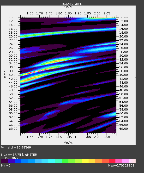
| Estimated Moho Depth: |
37.75 km |
| Estimated Crust Vp/Vs: |
1.70 |
| Assumed Crust Vp: |
6.264 km/s |
| Estimated Crust Vs: |
3.695 km/s |
| Estimated Crust Poisson's Ratio: |
0.23 |
|
| Radial Match: |
86.98569 % |
| Radial Bump: |
400 |
| Transverse Match: |
81.62354 % |
| Transverse Bump: |
400 |
| SOD ConfigId: |
6273 |
| Insert Time: |
2010-02-26 14:08:19.952 +0000 |
| GWidth: |
2.5 |
| Max Bumps: |
400 |
| Tol: |
0.001 |
|
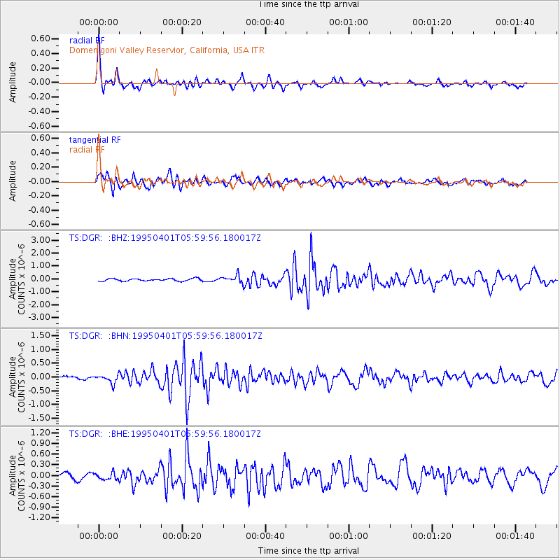
Signal To Noise
| Channel | StoN | STA | LTA |
| TS:DGR: :BHN:19950401T05:59:56.180017Z | 1.5241606 | 1.5454734E-7 | 1.0139833E-7 |
| TS:DGR: :BHE:19950401T05:59:56.180017Z | 1.1342844 | 9.886333E-8 | 8.715921E-8 |
| TS:DGR: :BHZ:19950401T05:59:56.180017Z | 3.1310916 | 3.0212726E-7 | 9.649263E-8 |
| Arrivals |
| Ps | 4.4 SECOND |
| PpPs | 16 SECOND |
| PsPs/PpSs | 20 SECOND |


