You are here: Home > Network List > TA - USArray Transportable Network (new EarthScope stations) Stations List
> Station V25A Rancho No Tengo, Wagon Mound, NM, USA > Earthquake Result Viewer
V25A Rancho No Tengo, Wagon Mound, NM, USA - Earthquake Result Viewer
| Earthquake location: |
Central Mid-Atlantic Ridge |
| Earthquake latitude/longitude: |
7.3/-34.9 |
| Earthquake time(UTC): |
2008/05/23 (144) 19:35:34 GMT |
| Earthquake Depth: |
9.0 km |
| Earthquake Magnitude: |
6.0 MB, 6.4 MS, 6.5 MW, 6.5 MW |
| Earthquake Catalog/Contributor: |
WHDF/NEIC |
|
| Network: |
TA USArray Transportable Network (new EarthScope stations) |
| Station: |
V25A Rancho No Tengo, Wagon Mound, NM, USA |
| Lat/Lon: |
35.84 N/104.62 W |
| Elevation: |
1861 m |
|
| Distance: |
69.3 deg |
| Az: |
305.449 deg |
| Baz: |
95.993 deg |
| Ray Param: |
0.05572534 |
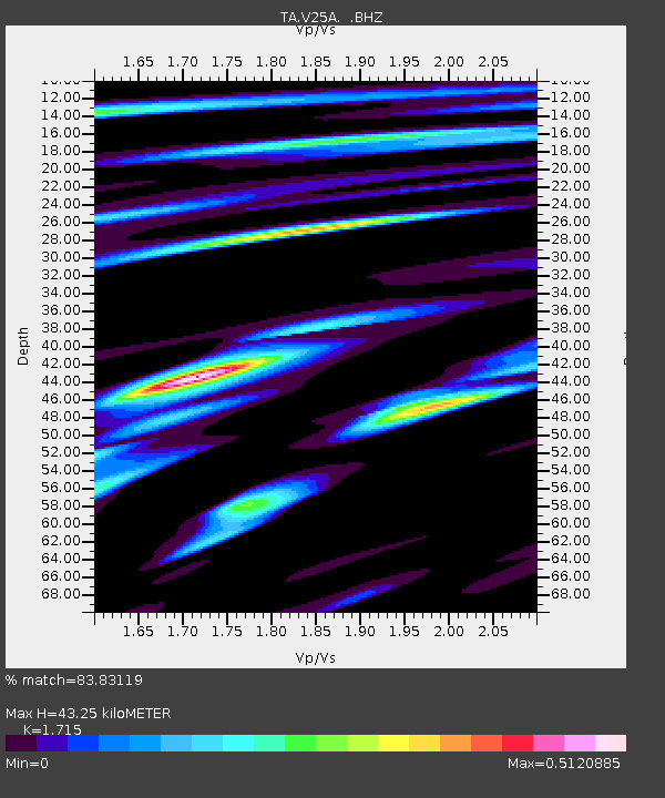
| Estimated Moho Depth: |
43.25 km |
| Estimated Crust Vp/Vs: |
1.72 |
| Assumed Crust Vp: |
6.419 km/s |
| Estimated Crust Vs: |
3.743 km/s |
| Estimated Crust Poisson's Ratio: |
0.24 |
|
| Radial Match: |
83.83119 % |
| Radial Bump: |
400 |
| Transverse Match: |
76.56583 % |
| Transverse Bump: |
400 |
| SOD ConfigId: |
2504 |
| Insert Time: |
2010-03-06 20:56:41.287 +0000 |
| GWidth: |
2.5 |
| Max Bumps: |
400 |
| Tol: |
0.001 |
|

Signal To Noise
| Channel | StoN | STA | LTA |
| TA:V25A: :BHZ:20080523T19:46:11.374021Z | 3.4422 | 5.2722766E-7 | 1.5316589E-7 |
| TA:V25A: :BHN:20080523T19:46:11.374021Z | 0.4846671 | 5.7420888E-8 | 1.184749E-7 |
| TA:V25A: :BHE:20080523T19:46:11.374021Z | 1.7218293 | 3.8953252E-7 | 2.2623178E-7 |
| Arrivals |
| Ps | 5.0 SECOND |
| PpPs | 18 SECOND |
| PsPs/PpSs | 23 SECOND |


