You are here: Home > Network List > TS - TERRAscope (Southern California Seismic Network) Stations List
> Station DGR Domenigoni Valley Reservior, California, USA > Earthquake Result Viewer
DGR Domenigoni Valley Reservior, California, USA - Earthquake Result Viewer
| Earthquake location: |
Sea Of Japan |
| Earthquake latitude/longitude: |
38.2/135.1 |
| Earthquake time(UTC): |
1995/03/31 (090) 14:01:40 GMT |
| Earthquake Depth: |
365 km |
| Earthquake Magnitude: |
6.0 MB, 6.2 UNKNOWN, 6.3 MW |
| Earthquake Catalog/Contributor: |
WHDF/NEIC |
|
| Network: |
TS TERRAscope (Southern California Seismic Network) |
| Station: |
DGR Domenigoni Valley Reservior, California, USA |
| Lat/Lon: |
33.65 N/117.01 W |
| Elevation: |
700 m |
|
| Distance: |
82.1 deg |
| Az: |
53.24 deg |
| Baz: |
310.78 deg |
| Ray Param: |
0.046120115 |
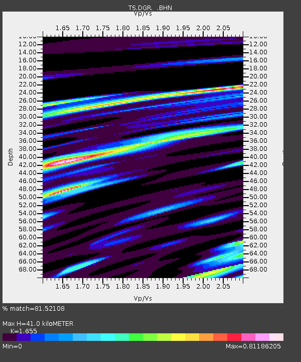
| Estimated Moho Depth: |
41.0 km |
| Estimated Crust Vp/Vs: |
1.65 |
| Assumed Crust Vp: |
6.264 km/s |
| Estimated Crust Vs: |
3.785 km/s |
| Estimated Crust Poisson's Ratio: |
0.21 |
|
| Radial Match: |
81.52108 % |
| Radial Bump: |
400 |
| Transverse Match: |
60.061775 % |
| Transverse Bump: |
400 |
| SOD ConfigId: |
6273 |
| Insert Time: |
2010-02-26 14:08:21.700 +0000 |
| GWidth: |
2.5 |
| Max Bumps: |
400 |
| Tol: |
0.001 |
|

Signal To Noise
| Channel | StoN | STA | LTA |
| TS:DGR: :BHN:19950331T14:12:50.479016Z | 3.9286954 | 3.6833453E-7 | 9.375492E-8 |
| TS:DGR: :BHE:19950331T14:12:50.479016Z | 4.5872846 | 3.9843027E-7 | 8.6855366E-8 |
| TS:DGR: :BHZ:19950331T14:12:50.479016Z | 16.857544 | 1.3254959E-6 | 7.862924E-8 |
| Arrivals |
| Ps | 4.4 SECOND |
| PpPs | 17 SECOND |
| PsPs/PpSs | 21 SECOND |


