You are here: Home > Network List > TA - USArray Transportable Network (new EarthScope stations) Stations List
> Station V25A Rancho No Tengo, Wagon Mound, NM, USA > Earthquake Result Viewer
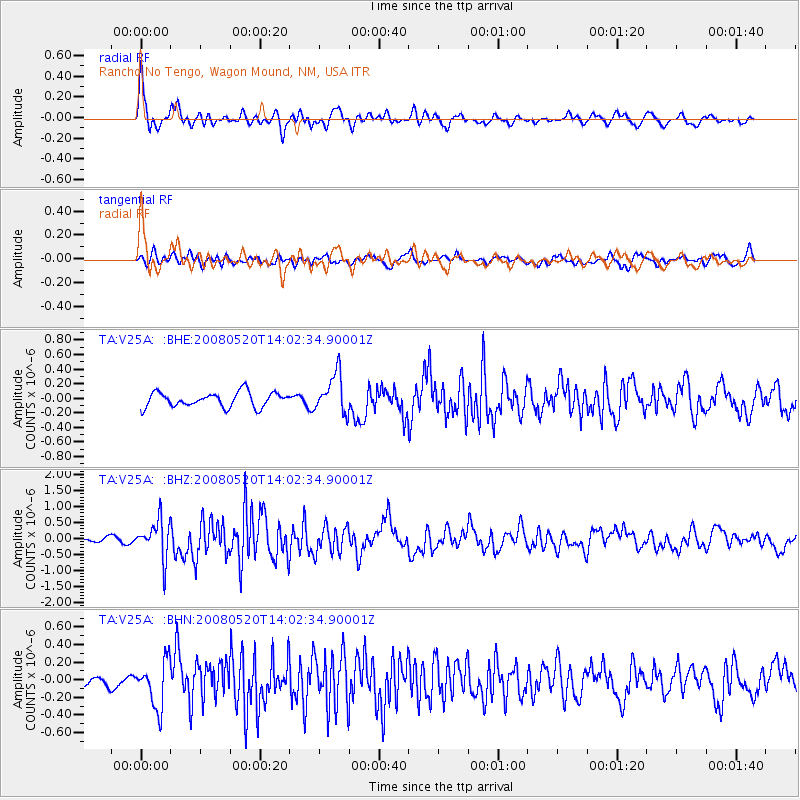
V25A Rancho No Tengo, Wagon Mound, NM, USA - Earthquake Result Viewer
*The percent match for this event was below the threshold and hence no stack was calculated.
| Earthquake location: |
Rat Islands, Aleutian Islands |
| Earthquake latitude/longitude: |
51.2/178.8 |
| Earthquake time(UTC): |
2008/05/20 (141) 13:53:35 GMT |
| Earthquake Depth: |
27 km |
| Earthquake Magnitude: |
5.8 MB, 6.0 MS, 6.3 MW, 6.3 MW |
| Earthquake Catalog/Contributor: |
WHDF/NEIC |
|
| Network: |
TA USArray Transportable Network (new EarthScope stations) |
| Station: |
V25A Rancho No Tengo, Wagon Mound, NM, USA |
| Lat/Lon: |
35.84 N/104.62 W |
| Elevation: |
1861 m |
|
| Distance: |
55.2 deg |
| Az: |
74.379 deg |
| Baz: |
311.727 deg |
| Ray Param: |
$rayparam |
*The percent match for this event was below the threshold and hence was not used in the summary stack. |
|
| Radial Match: |
72.83842 % |
| Radial Bump: |
400 |
| Transverse Match: |
76.68921 % |
| Transverse Bump: |
400 |
| SOD ConfigId: |
2504 |
| Insert Time: |
2010-03-06 20:56:53.795 +0000 |
| GWidth: |
2.5 |
| Max Bumps: |
400 |
| Tol: |
0.001 |
|
Signal To Noise
| Channel | StoN | STA | LTA |
| TA:V25A: :BHZ:20080520T14:02:34.90001Z | 5.148595 | 5.911438E-7 | 1.1481654E-7 |
| TA:V25A: :BHN:20080520T14:02:34.90001Z | 4.3403087 | 2.641818E-7 | 6.086705E-8 |
| TA:V25A: :BHE:20080520T14:02:34.90001Z | 2.6756706 | 2.7011558E-7 | 1.0095248E-7 |
| Arrivals |
| Ps | |
| PpPs | |
| PsPs/PpSs | |


