You are here: Home > Network List > US - United States National Seismic Network Stations List
> Station LAO LASA Array, Montana, USA > Earthquake Result Viewer
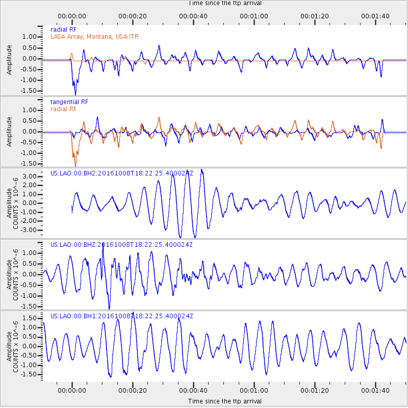
LAO LASA Array, Montana, USA - Earthquake Result Viewer
*The percent match for this event was below the threshold and hence no stack was calculated.
| Earthquake location: |
Mariana Islands Region |
| Earthquake latitude/longitude: |
20.0/146.8 |
| Earthquake time(UTC): |
2016/10/08 (282) 18:10:13 GMT |
| Earthquake Depth: |
10 km |
| Earthquake Magnitude: |
5.6 MB, 5.6 MB |
| Earthquake Catalog/Contributor: |
NEIC PDE/NEIC ALERT |
|
| Network: |
US United States National Seismic Network |
| Station: |
LAO LASA Array, Montana, USA |
| Lat/Lon: |
46.69 N/106.22 W |
| Elevation: |
902 m |
|
| Distance: |
86.7 deg |
| Az: |
41.253 deg |
| Baz: |
295.756 deg |
| Ray Param: |
$rayparam |
*The percent match for this event was below the threshold and hence was not used in the summary stack. |
|
| Radial Match: |
62.29584 % |
| Radial Bump: |
388 |
| Transverse Match: |
62.448822 % |
| Transverse Bump: |
400 |
| SOD ConfigId: |
1634031 |
| Insert Time: |
2016-10-22 18:15:11.052 +0000 |
| GWidth: |
2.5 |
| Max Bumps: |
400 |
| Tol: |
0.001 |
|
Signal To Noise
| Channel | StoN | STA | LTA |
| US:LAO:00:BHZ:20161008T18:22:25.400024Z | 2.6463463 | 6.3199013E-7 | 2.388161E-7 |
| US:LAO:00:BH1:20161008T18:22:25.400024Z | 0.700542 | 4.4350625E-7 | 6.330902E-7 |
| US:LAO:00:BH2:20161008T18:22:25.400024Z | 2.7015176 | 2.0607126E-6 | 7.6279815E-7 |
| Arrivals |
| Ps | |
| PpPs | |
| PsPs/PpSs | |


