You are here: Home > Network List > UW - Pacific Northwest Regional Seismic Network Stations List
> Station WAT2 Waterville, WA, USA > Earthquake Result Viewer
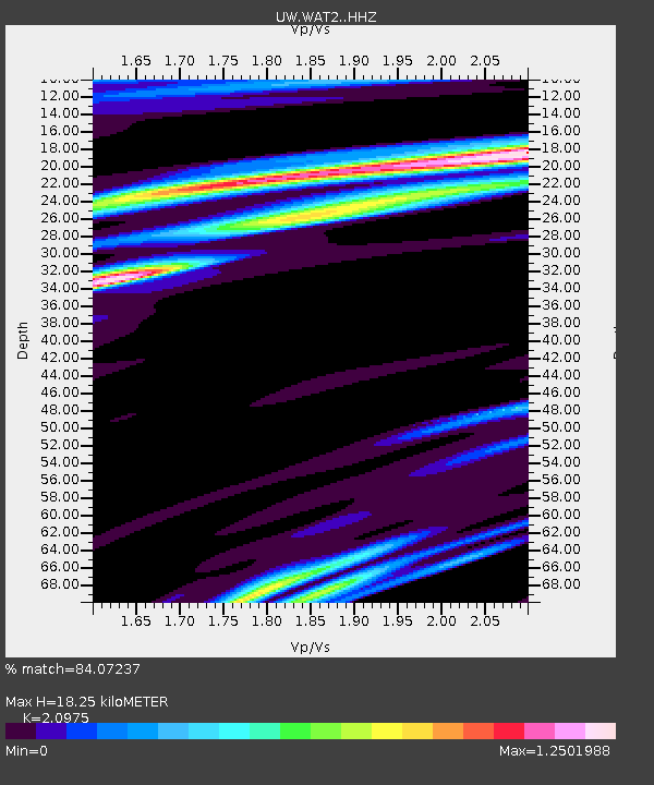
WAT2 Waterville, WA, USA - Earthquake Result Viewer
| Earthquake location: |
Colombia |
| Earthquake latitude/longitude: |
4.6/-76.3 |
| Earthquake time(UTC): |
2019/03/23 (082) 19:21:16 GMT |
| Earthquake Depth: |
113 km |
| Earthquake Magnitude: |
6.1 Mww |
| Earthquake Catalog/Contributor: |
NEIC PDE/us |
|
| Network: |
UW Pacific Northwest Regional Seismic Network |
| Station: |
WAT2 Waterville, WA, USA |
| Lat/Lon: |
47.62 N/120.11 W |
| Elevation: |
875 m |
|
| Distance: |
57.0 deg |
| Az: |
326.037 deg |
| Baz: |
124.592 deg |
| Ray Param: |
0.06343359 |
| Estimated Moho Depth: |
18.25 km |
| Estimated Crust Vp/Vs: |
2.10 |
| Assumed Crust Vp: |
6.597 km/s |
| Estimated Crust Vs: |
3.145 km/s |
| Estimated Crust Poisson's Ratio: |
0.35 |
|
| Radial Match: |
84.07237 % |
| Radial Bump: |
350 |
| Transverse Match: |
51.865383 % |
| Transverse Bump: |
400 |
| SOD ConfigId: |
13570011 |
| Insert Time: |
2019-05-02 19:14:34.483 +0000 |
| GWidth: |
2.5 |
| Max Bumps: |
400 |
| Tol: |
0.001 |
|

Signal To Noise
| Channel | StoN | STA | LTA |
| UW:WAT2: :HHZ:20190323T19:30:20.500015Z | 3.9541407 | 1.7976612E-6 | 4.5462752E-7 |
| UW:WAT2: :HHN:20190323T19:30:20.500015Z | 1.2977117 | 9.23319E-7 | 7.1149776E-7 |
| UW:WAT2: :HHE:20190323T19:30:20.500015Z | 2.591905 | 9.920805E-7 | 3.8276107E-7 |
| Arrivals |
| Ps | 3.2 SECOND |
| PpPs | 8.2 SECOND |
| PsPs/PpSs | 11 SECOND |


