You are here: Home > Network List > TA - USArray Transportable Network (new EarthScope stations) Stations List
> Station B18K Kokolik River, AK, USA > Earthquake Result Viewer
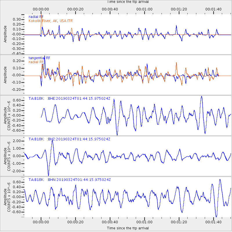
B18K Kokolik River, AK, USA - Earthquake Result Viewer
*The percent match for this event was below the threshold and hence no stack was calculated.
| Earthquake location: |
Sulawesi, Indonesia |
| Earthquake latitude/longitude: |
-1.8/120.5 |
| Earthquake time(UTC): |
2019/03/24 (083) 01:31:59 GMT |
| Earthquake Depth: |
10 km |
| Earthquake Magnitude: |
5.4 Mww |
| Earthquake Catalog/Contributor: |
NEIC PDE/us |
|
| Network: |
TA USArray Transportable Network (new EarthScope stations) |
| Station: |
B18K Kokolik River, AK, USA |
| Lat/Lon: |
69.36 N/161.80 W |
| Elevation: |
222 m |
|
| Distance: |
87.4 deg |
| Az: |
20.284 deg |
| Baz: |
257.802 deg |
| Ray Param: |
$rayparam |
*The percent match for this event was below the threshold and hence was not used in the summary stack. |
|
| Radial Match: |
71.64121 % |
| Radial Bump: |
400 |
| Transverse Match: |
74.294624 % |
| Transverse Bump: |
400 |
| SOD ConfigId: |
13570011 |
| Insert Time: |
2019-05-02 19:18:28.658 +0000 |
| GWidth: |
2.5 |
| Max Bumps: |
400 |
| Tol: |
0.001 |
|
Signal To Noise
| Channel | StoN | STA | LTA |
| TA:B18K: :BHZ:20190324T01:44:15.975024Z | 2.6093795 | 9.550913E-7 | 3.6602236E-7 |
| TA:B18K: :BHN:20190324T01:44:15.975024Z | 0.9256263 | 1.9686398E-7 | 2.1268193E-7 |
| TA:B18K: :BHE:20190324T01:44:15.975024Z | 1.1680567 | 2.0472929E-7 | 1.7527341E-7 |
| Arrivals |
| Ps | |
| PpPs | |
| PsPs/PpSs | |


