You are here: Home > Network List > TA - USArray Transportable Network (new EarthScope stations) Stations List
> Station F21K Alatna River, AK, USA > Earthquake Result Viewer
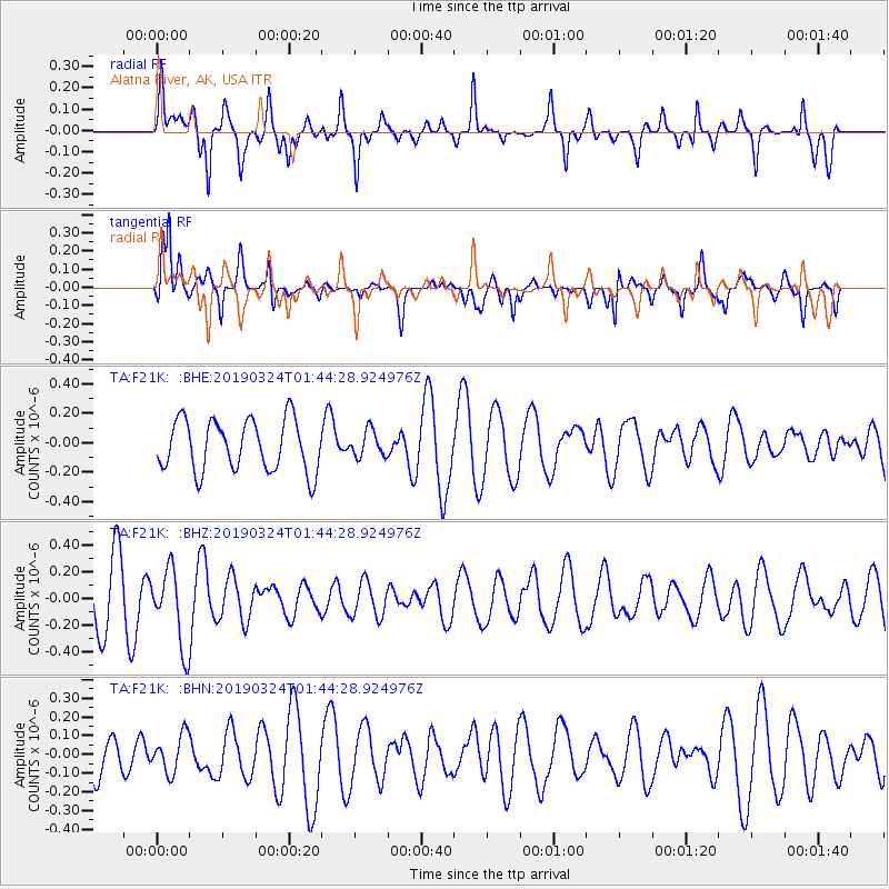
F21K Alatna River, AK, USA - Earthquake Result Viewer
*The percent match for this event was below the threshold and hence no stack was calculated.
| Earthquake location: |
Sulawesi, Indonesia |
| Earthquake latitude/longitude: |
-1.8/120.5 |
| Earthquake time(UTC): |
2019/03/24 (083) 01:31:59 GMT |
| Earthquake Depth: |
10 km |
| Earthquake Magnitude: |
5.4 Mww |
| Earthquake Catalog/Contributor: |
NEIC PDE/us |
|
| Network: |
TA USArray Transportable Network (new EarthScope stations) |
| Station: |
F21K Alatna River, AK, USA |
| Lat/Lon: |
67.22 N/153.48 W |
| Elevation: |
597 m |
|
| Distance: |
90.1 deg |
| Az: |
22.856 deg |
| Baz: |
265.583 deg |
| Ray Param: |
$rayparam |
*The percent match for this event was below the threshold and hence was not used in the summary stack. |
|
| Radial Match: |
57.153717 % |
| Radial Bump: |
384 |
| Transverse Match: |
61.41734 % |
| Transverse Bump: |
396 |
| SOD ConfigId: |
13570011 |
| Insert Time: |
2019-05-02 19:18:44.123 +0000 |
| GWidth: |
2.5 |
| Max Bumps: |
400 |
| Tol: |
0.001 |
|
Signal To Noise
| Channel | StoN | STA | LTA |
| TA:F21K: :BHZ:20190324T01:44:28.924976Z | 1.4404907 | 2.929464E-7 | 2.0336569E-7 |
| TA:F21K: :BHN:20190324T01:44:28.924976Z | 0.5743031 | 1.0027437E-7 | 1.7460182E-7 |
| TA:F21K: :BHE:20190324T01:44:28.924976Z | 0.49690846 | 8.647924E-8 | 1.7403455E-7 |
| Arrivals |
| Ps | |
| PpPs | |
| PsPs/PpSs | |


