You are here: Home > Network List > TS - TERRAscope (Southern California Seismic Network) Stations List
> Station DGR Domenigoni Valley Reservior, California, USA > Earthquake Result Viewer
DGR Domenigoni Valley Reservior, California, USA - Earthquake Result Viewer
| Earthquake location: |
Colombia |
| Earthquake latitude/longitude: |
5.1/-72.9 |
| Earthquake time(UTC): |
1995/01/19 (019) 15:05:03 GMT |
| Earthquake Depth: |
18 km |
| Earthquake Magnitude: |
6.4 MB, 6.6 MS, 6.5 UNKNOWN, 6.5 MW |
| Earthquake Catalog/Contributor: |
WHDF/NEIC |
|
| Network: |
TS TERRAscope (Southern California Seismic Network) |
| Station: |
DGR Domenigoni Valley Reservior, California, USA |
| Lat/Lon: |
33.65 N/117.01 W |
| Elevation: |
700 m |
|
| Distance: |
49.8 deg |
| Az: |
310.56 deg |
| Baz: |
114.871 deg |
| Ray Param: |
0.06844108 |
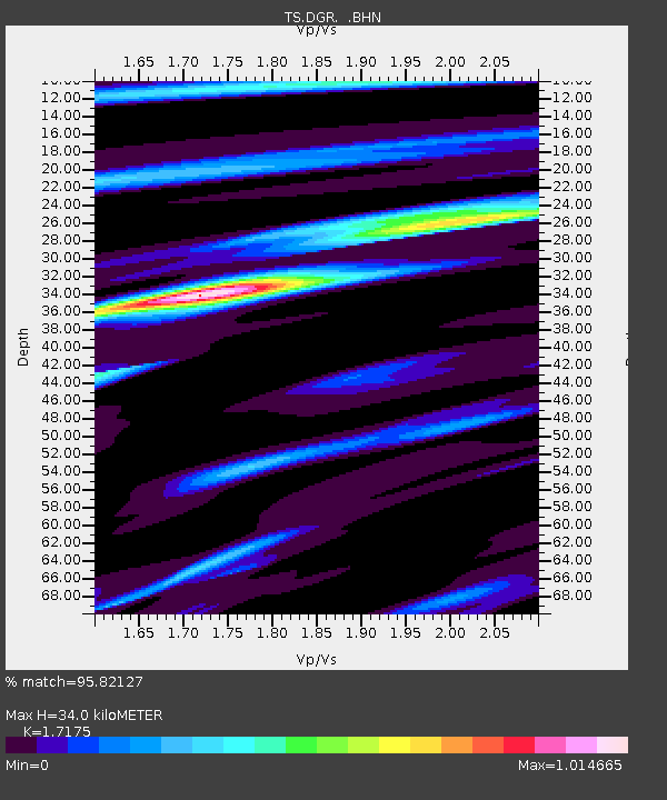
| Estimated Moho Depth: |
34.0 km |
| Estimated Crust Vp/Vs: |
1.72 |
| Assumed Crust Vp: |
6.264 km/s |
| Estimated Crust Vs: |
3.647 km/s |
| Estimated Crust Poisson's Ratio: |
0.24 |
|
| Radial Match: |
95.82127 % |
| Radial Bump: |
262 |
| Transverse Match: |
82.40858 % |
| Transverse Bump: |
400 |
| SOD ConfigId: |
6273 |
| Insert Time: |
2010-02-26 14:08:26.800 +0000 |
| GWidth: |
2.5 |
| Max Bumps: |
400 |
| Tol: |
0.001 |
|

Signal To Noise
| Channel | StoN | STA | LTA |
| TS:DGR: :BHN:19950119T15:13:24.428003Z | 1.7016264 | 4.0947702E-7 | 2.406386E-7 |
| TS:DGR: :BHE:19950119T15:13:24.428003Z | 5.8382907 | 8.2679253E-7 | 1.4161552E-7 |
| TS:DGR: :BHZ:19950119T15:13:24.428003Z | 4.331336 | 1.2353653E-6 | 2.8521575E-7 |
| Arrivals |
| Ps | 4.1 SECOND |
| PpPs | 14 SECOND |
| PsPs/PpSs | 18 SECOND |


