You are here: Home > Network List > TS - TERRAscope (Southern California Seismic Network) Stations List
> Station DGR Domenigoni Valley Reservior, California, USA > Earthquake Result Viewer
DGR Domenigoni Valley Reservior, California, USA - Earthquake Result Viewer

| Earthquake location: |
Off E. Coast Of N. Island, N.Z. |
| Earthquake latitude/longitude: |
-37.7/178.8 |
| Earthquake time(UTC): |
1995/02/05 (036) 22:51:10 GMT |
| Earthquake Depth: |
59 km |
| Earthquake Magnitude: |
6.4 MB, 7.1 UNKNOWN, 7.1 MW |
| Earthquake Catalog/Contributor: |
WHDF/NEIC |
|
| Network: |
TS TERRAscope (Southern California Seismic Network) |
| Station: |
DGR Domenigoni Valley Reservior, California, USA |
| Lat/Lon: |
33.65 N/117.01 W |
| Elevation: |
700 m |
|
| Distance: |
92.8 deg |
| Az: |
48.765 deg |
| Baz: |
225.641 deg |
| Ray Param: |
0.04136612 |
| Estimated Moho Depth: |
31.75 km |
| Estimated Crust Vp/Vs: |
1.86 |
| Assumed Crust Vp: |
6.264 km/s |
| Estimated Crust Vs: |
3.368 km/s |
| Estimated Crust Poisson's Ratio: |
0.30 |
|
| Radial Match: |
91.733406 % |
| Radial Bump: |
332 |
| Transverse Match: |
87.67077 % |
| Transverse Bump: |
400 |
| SOD ConfigId: |
6273 |
| Insert Time: |
2010-02-26 14:08:29.671 +0000 |
| GWidth: |
2.5 |
| Max Bumps: |
400 |
| Tol: |
0.001 |
|
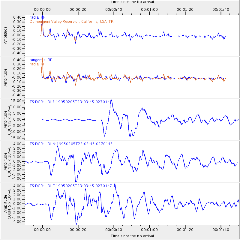
Signal To Noise
| Channel | StoN | STA | LTA |
| TS:DGR: :BHN:19950205T23:03:45.027014Z | 6.9365487 | 9.651958E-7 | 1.3914641E-7 |
| TS:DGR: :BHE:19950205T23:03:45.027014Z | 6.652009 | 9.5162994E-7 | 1.4305903E-7 |
| TS:DGR: :BHZ:19950205T23:03:45.027014Z | 10.354039 | 4.0074765E-6 | 3.8704474E-7 |
| Arrivals |
| Ps | 4.4 SECOND |
| PpPs | 14 SECOND |
| PsPs/PpSs | 19 SECOND |


