You are here: Home > Network List > TA - USArray Transportable Network (new EarthScope stations) Stations List
> Station V25A Rancho No Tengo, Wagon Mound, NM, USA > Earthquake Result Viewer
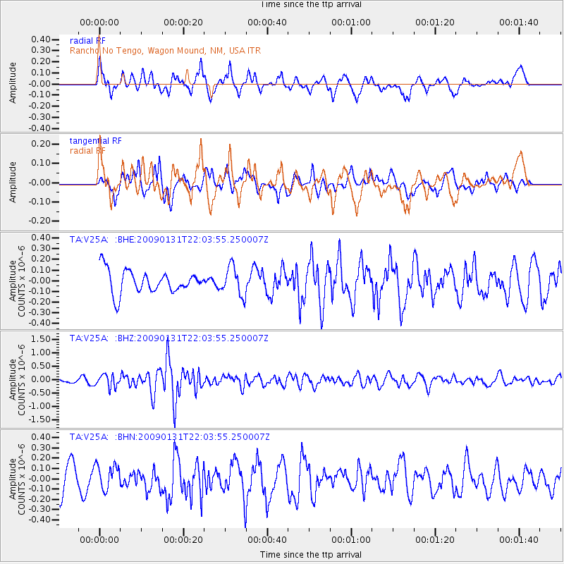
V25A Rancho No Tengo, Wagon Mound, NM, USA - Earthquake Result Viewer
*The percent match for this event was below the threshold and hence no stack was calculated.
| Earthquake location: |
Near East Coast Of Honshu, Japan |
| Earthquake latitude/longitude: |
36.7/141.1 |
| Earthquake time(UTC): |
2009/01/31 (031) 21:51:52 GMT |
| Earthquake Depth: |
34 km |
| Earthquake Magnitude: |
5.6 MB, 5.3 MS, 5.8 MW, 5.7 MW |
| Earthquake Catalog/Contributor: |
WHDF/NEIC |
|
| Network: |
TA USArray Transportable Network (new EarthScope stations) |
| Station: |
V25A Rancho No Tengo, Wagon Mound, NM, USA |
| Lat/Lon: |
35.84 N/104.62 W |
| Elevation: |
1861 m |
|
| Distance: |
85.5 deg |
| Az: |
48.009 deg |
| Baz: |
312.695 deg |
| Ray Param: |
$rayparam |
*The percent match for this event was below the threshold and hence was not used in the summary stack. |
|
| Radial Match: |
74.956474 % |
| Radial Bump: |
400 |
| Transverse Match: |
66.43381 % |
| Transverse Bump: |
400 |
| SOD ConfigId: |
2658 |
| Insert Time: |
2010-03-06 20:57:44.646 +0000 |
| GWidth: |
2.5 |
| Max Bumps: |
400 |
| Tol: |
0.001 |
|
Signal To Noise
| Channel | StoN | STA | LTA |
| TA:V25A: :BHZ:20090131T22:03:55.250007Z | 2.2949092 | 2.266856E-7 | 9.877759E-8 |
| TA:V25A: :BHN:20090131T22:03:55.250007Z | 1.0327209 | 1.18443495E-7 | 1.1469071E-7 |
| TA:V25A: :BHE:20090131T22:03:55.250007Z | 1.2896478 | 1.3840736E-7 | 1.07321824E-7 |
| Arrivals |
| Ps | |
| PpPs | |
| PsPs/PpSs | |


