You are here: Home > Network List > TA - USArray Transportable Network (new EarthScope stations) Stations List
> Station H16K Elim, AK, USA > Earthquake Result Viewer
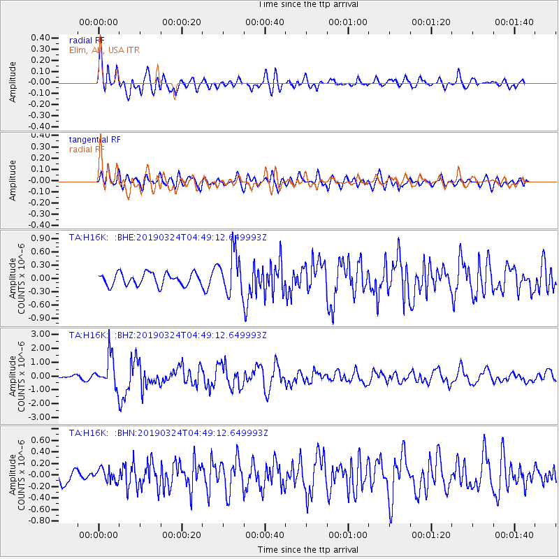
H16K Elim, AK, USA - Earthquake Result Viewer
*The percent match for this event was below the threshold and hence no stack was calculated.
| Earthquake location: |
Northern Molucca Sea |
| Earthquake latitude/longitude: |
1.7/126.4 |
| Earthquake time(UTC): |
2019/03/24 (083) 04:37:34 GMT |
| Earthquake Depth: |
37 km |
| Earthquake Magnitude: |
6.1 Mww |
| Earthquake Catalog/Contributor: |
NEIC PDE/us |
|
| Network: |
TA USArray Transportable Network (new EarthScope stations) |
| Station: |
H16K Elim, AK, USA |
| Lat/Lon: |
64.64 N/162.24 W |
| Elevation: |
216 m |
|
| Distance: |
80.5 deg |
| Az: |
24.436 deg |
| Baz: |
253.757 deg |
| Ray Param: |
$rayparam |
*The percent match for this event was below the threshold and hence was not used in the summary stack. |
|
| Radial Match: |
73.60081 % |
| Radial Bump: |
400 |
| Transverse Match: |
65.08555 % |
| Transverse Bump: |
400 |
| SOD ConfigId: |
13570011 |
| Insert Time: |
2019-05-02 19:23:49.232 +0000 |
| GWidth: |
2.5 |
| Max Bumps: |
400 |
| Tol: |
0.001 |
|
Signal To Noise
| Channel | StoN | STA | LTA |
| TA:H16K: :BHZ:20190324T04:49:12.649993Z | 8.462914 | 1.1812882E-6 | 1.3958409E-7 |
| TA:H16K: :BHN:20190324T04:49:12.649993Z | 0.7708542 | 1.1035243E-7 | 1.4315604E-7 |
| TA:H16K: :BHE:20190324T04:49:12.649993Z | 3.369211 | 4.6202024E-7 | 1.371301E-7 |
| Arrivals |
| Ps | |
| PpPs | |
| PsPs/PpSs | |


