You are here: Home > Network List > TA - USArray Transportable Network (new EarthScope stations) Stations List
> Station J17K VABM Dome, AK, USA > Earthquake Result Viewer
J17K VABM Dome, AK, USA - Earthquake Result Viewer
| Earthquake location: |
Northern Molucca Sea |
| Earthquake latitude/longitude: |
1.7/126.4 |
| Earthquake time(UTC): |
2019/03/24 (083) 04:37:34 GMT |
| Earthquake Depth: |
37 km |
| Earthquake Magnitude: |
6.1 Mww |
| Earthquake Catalog/Contributor: |
NEIC PDE/us |
|
| Network: |
TA USArray Transportable Network (new EarthScope stations) |
| Station: |
J17K VABM Dome, AK, USA |
| Lat/Lon: |
63.40 N/159.08 W |
| Elevation: |
323 m |
|
| Distance: |
81.6 deg |
| Az: |
26.014 deg |
| Baz: |
256.841 deg |
| Ray Param: |
0.047443062 |
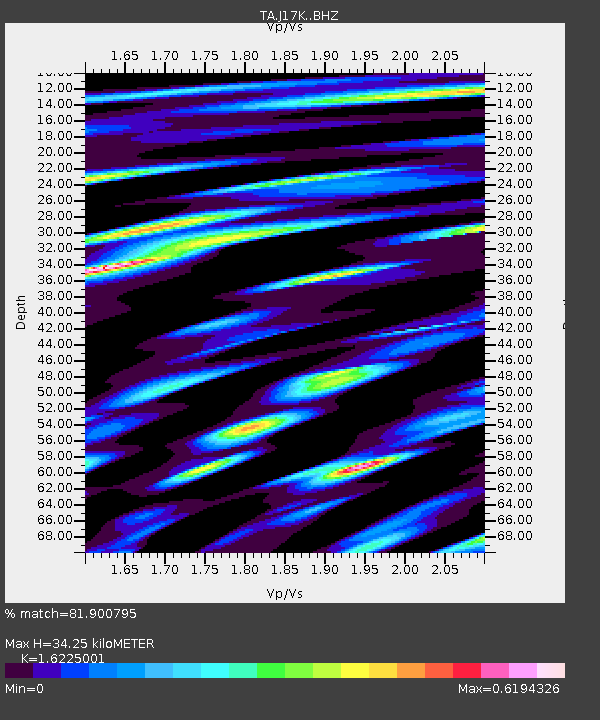
| Estimated Moho Depth: |
34.25 km |
| Estimated Crust Vp/Vs: |
1.62 |
| Assumed Crust Vp: |
6.276 km/s |
| Estimated Crust Vs: |
3.868 km/s |
| Estimated Crust Poisson's Ratio: |
0.19 |
|
| Radial Match: |
81.900795 % |
| Radial Bump: |
400 |
| Transverse Match: |
74.3675 % |
| Transverse Bump: |
400 |
| SOD ConfigId: |
13570011 |
| Insert Time: |
2019-05-02 19:24:05.311 +0000 |
| GWidth: |
2.5 |
| Max Bumps: |
400 |
| Tol: |
0.001 |
|

Signal To Noise
| Channel | StoN | STA | LTA |
| TA:J17K: :BHZ:20190324T04:49:18.100005Z | 14.180664 | 2.1524788E-6 | 1.517897E-7 |
| TA:J17K: :BHN:20190324T04:49:18.100005Z | 0.9384943 | 2.432078E-7 | 2.591468E-7 |
| TA:J17K: :BHE:20190324T04:49:18.100005Z | 7.2617774 | 9.548097E-7 | 1.314843E-7 |
| Arrivals |
| Ps | 3.5 SECOND |
| PpPs | 14 SECOND |
| PsPs/PpSs | 17 SECOND |


