You are here: Home > Network List > TA - USArray Transportable Network (new EarthScope stations) Stations List
> Station K17K Iditarod, AK, USA > Earthquake Result Viewer
K17K Iditarod, AK, USA - Earthquake Result Viewer
| Earthquake location: |
Northern Molucca Sea |
| Earthquake latitude/longitude: |
1.7/126.4 |
| Earthquake time(UTC): |
2019/03/24 (083) 04:37:34 GMT |
| Earthquake Depth: |
37 km |
| Earthquake Magnitude: |
6.1 Mww |
| Earthquake Catalog/Contributor: |
NEIC PDE/us |
|
| Network: |
TA USArray Transportable Network (new EarthScope stations) |
| Station: |
K17K Iditarod, AK, USA |
| Lat/Lon: |
62.72 N/158.30 W |
| Elevation: |
339 m |
|
| Distance: |
81.8 deg |
| Az: |
26.766 deg |
| Baz: |
257.641 deg |
| Ray Param: |
0.04730688 |
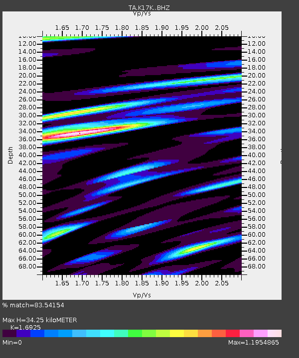
| Estimated Moho Depth: |
34.25 km |
| Estimated Crust Vp/Vs: |
1.69 |
| Assumed Crust Vp: |
6.276 km/s |
| Estimated Crust Vs: |
3.708 km/s |
| Estimated Crust Poisson's Ratio: |
0.23 |
|
| Radial Match: |
83.54154 % |
| Radial Bump: |
400 |
| Transverse Match: |
76.57094 % |
| Transverse Bump: |
400 |
| SOD ConfigId: |
13570011 |
| Insert Time: |
2019-05-02 19:24:11.724 +0000 |
| GWidth: |
2.5 |
| Max Bumps: |
400 |
| Tol: |
0.001 |
|

Signal To Noise
| Channel | StoN | STA | LTA |
| TA:K17K: :BHZ:20190324T04:49:19.125029Z | 10.283498 | 2.5935894E-6 | 2.522089E-7 |
| TA:K17K: :BHN:20190324T04:49:19.125029Z | 1.3409566 | 3.439428E-7 | 2.564906E-7 |
| TA:K17K: :BHE:20190324T04:49:19.125029Z | 2.327546 | 7.7968133E-7 | 3.3498E-7 |
| Arrivals |
| Ps | 3.9 SECOND |
| PpPs | 14 SECOND |
| PsPs/PpSs | 18 SECOND |


