You are here: Home > Network List > TS - TERRAscope (Southern California Seismic Network) Stations List
> Station DGR Domenigoni Valley Reservior, California, USA > Earthquake Result Viewer
DGR Domenigoni Valley Reservior, California, USA - Earthquake Result Viewer
| Earthquake location: |
New Ireland Region, P.N.G. |
| Earthquake latitude/longitude: |
-4.0/153.9 |
| Earthquake time(UTC): |
1995/06/24 (175) 06:58:06 GMT |
| Earthquake Depth: |
386 km |
| Earthquake Magnitude: |
6.2 MB, 6.8 UNKNOWN |
| Earthquake Catalog/Contributor: |
WHDF/NEIC |
|
| Network: |
TS TERRAscope (Southern California Seismic Network) |
| Station: |
DGR Domenigoni Valley Reservior, California, USA |
| Lat/Lon: |
33.65 N/117.01 W |
| Elevation: |
700 m |
|
| Distance: |
91.4 deg |
| Az: |
56.541 deg |
| Baz: |
266.177 deg |
| Ray Param: |
0.041406408 |
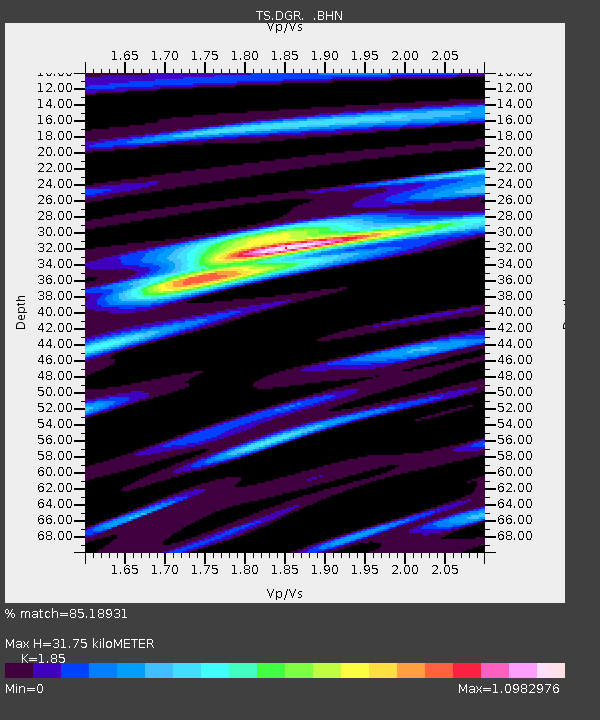
| Estimated Moho Depth: |
31.75 km |
| Estimated Crust Vp/Vs: |
1.85 |
| Assumed Crust Vp: |
6.264 km/s |
| Estimated Crust Vs: |
3.386 km/s |
| Estimated Crust Poisson's Ratio: |
0.29 |
|
| Radial Match: |
85.18931 % |
| Radial Bump: |
400 |
| Transverse Match: |
66.96717 % |
| Transverse Bump: |
400 |
| SOD ConfigId: |
6273 |
| Insert Time: |
2010-02-26 14:08:33.651 +0000 |
| GWidth: |
2.5 |
| Max Bumps: |
400 |
| Tol: |
0.001 |
|
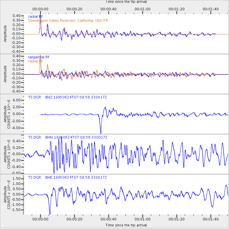
Signal To Noise
| Channel | StoN | STA | LTA |
| TS:DGR: :BHN:19950624T07:09:58.330017Z | 1.4382175 | 6.445445E-8 | 4.4815508E-8 |
| TS:DGR: :BHE:19950624T07:09:58.330017Z | 2.066981 | 1.3719874E-7 | 6.637639E-8 |
| TS:DGR: :BHZ:19950624T07:09:58.330017Z | 4.375614 | 4.1635784E-7 | 9.515415E-8 |
| Arrivals |
| Ps | 4.4 SECOND |
| PpPs | 14 SECOND |
| PsPs/PpSs | 19 SECOND |


