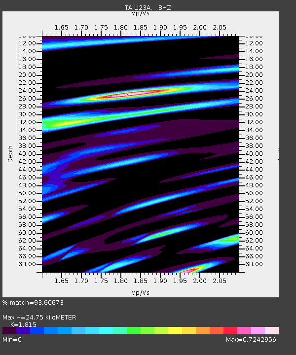
U23A El Rito, NM, USA - Earthquake Result Viewer
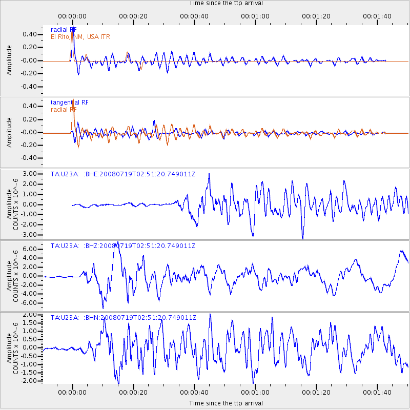
Earthquake location: Off East Coast Of Honshu, Japan
Earthquake latitude/longitude: 37.6/142.2
Earthquake time(UTC): 2008/07/19 (201) 02:39:28 GMT
Earthquake Depth: 22 km
Earthquake Magnitude: 6.2 MB, 7.0 MS, 7.0 MW, 6.9 MW
Earthquake Catalog/Contributor: WHDF/NEIC
Network: TA USArray Transportable Network (new EarthScope stations)
Station: U23A El Rito, NM, USA
Lat/Lon: 36.33 N/106.19 W
Elevation: 2093 m
Distance: 83.0 deg
Az: 49.155 deg
Baz: 311.881 deg
Ray Param: 0.04647146
Estimated Moho Depth: 24.75 km
Estimated Crust Vp/Vs: 1.82
Assumed Crust Vp: 6.159 km/s
Estimated Crust Vs: 3.393 km/s
Estimated Crust Poisson's Ratio: 0.28
Radial Match: 93.60673 %
Radial Bump: 400
Transverse Match: 83.381744 %
Transverse Bump: 400
SOD ConfigId: 2504
Insert Time: 2010-03-06 20:58:01.558 +0000
GWidth: 2.5
Max Bumps: 400
Tol: 0.001

Signal To Noise

ChannelStoNSTALTA
TA:U23A: :BHZ:20080719T02:51:20.749011Z6.0977095.1240886E-78.403301E-8
TA:U23A: :BHN:20080719T02:51:20.749011Z1.73212931.4730901E-78.5045045E-8
TA:U23A: :BHE:20080719T02:51:20.749011Z1.70017681.8420997E-71.08347535E-7
Arrivals
Ps3.4 SECOND
PpPs11 SECOND
PsPs/PpSs14 SECOND