You are here: Home > Network List > TA - USArray Transportable Network (new EarthScope stations) Stations List
> Station M31M Drury Creek, Yukon, CA > Earthquake Result Viewer
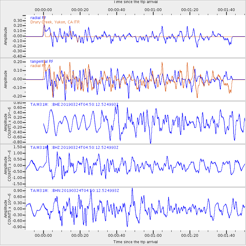
M31M Drury Creek, Yukon, CA - Earthquake Result Viewer
*The percent match for this event was below the threshold and hence no stack was calculated.
| Earthquake location: |
Northern Molucca Sea |
| Earthquake latitude/longitude: |
1.7/126.4 |
| Earthquake time(UTC): |
2019/03/24 (083) 04:37:34 GMT |
| Earthquake Depth: |
37 km |
| Earthquake Magnitude: |
6.1 Mww |
| Earthquake Catalog/Contributor: |
NEIC PDE/us |
|
| Network: |
TA USArray Transportable Network (new EarthScope stations) |
| Station: |
M31M Drury Creek, Yukon, CA |
| Lat/Lon: |
62.20 N/134.39 W |
| Elevation: |
639 m |
|
| Distance: |
92.8 deg |
| Az: |
27.603 deg |
| Baz: |
278.918 deg |
| Ray Param: |
$rayparam |
*The percent match for this event was below the threshold and hence was not used in the summary stack. |
|
| Radial Match: |
64.46198 % |
| Radial Bump: |
400 |
| Transverse Match: |
55.340397 % |
| Transverse Bump: |
400 |
| SOD ConfigId: |
13570011 |
| Insert Time: |
2019-05-02 19:24:31.366 +0000 |
| GWidth: |
2.5 |
| Max Bumps: |
400 |
| Tol: |
0.001 |
|
Signal To Noise
| Channel | StoN | STA | LTA |
| TA:M31M: :BHZ:20190324T04:50:12.524993Z | 3.0092785 | 6.4561937E-7 | 2.1454292E-7 |
| TA:M31M: :BHN:20190324T04:50:12.524993Z | 1.0159595 | 2.1109072E-7 | 2.0777473E-7 |
| TA:M31M: :BHE:20190324T04:50:12.524993Z | 1.0832239 | 2.8598262E-7 | 2.6401062E-7 |
| Arrivals |
| Ps | |
| PpPs | |
| PsPs/PpSs | |


