You are here: Home > Network List > TA - USArray Transportable Network (new EarthScope stations) Stations List
> Station U23A El Rito, NM, USA > Earthquake Result Viewer
U23A El Rito, NM, USA - Earthquake Result Viewer
| Earthquake location: |
Fiji Islands Region |
| Earthquake latitude/longitude: |
-17.3/-177.3 |
| Earthquake time(UTC): |
2008/07/19 (201) 22:39:52 GMT |
| Earthquake Depth: |
391 km |
| Earthquake Magnitude: |
5.9 MB, 6.4 MW, 6.4 MW |
| Earthquake Catalog/Contributor: |
WHDF/NEIC |
|
| Network: |
TA USArray Transportable Network (new EarthScope stations) |
| Station: |
U23A El Rito, NM, USA |
| Lat/Lon: |
36.33 N/106.19 W |
| Elevation: |
2093 m |
|
| Distance: |
85.7 deg |
| Az: |
50.016 deg |
| Baz: |
244.998 deg |
| Ray Param: |
0.043551076 |
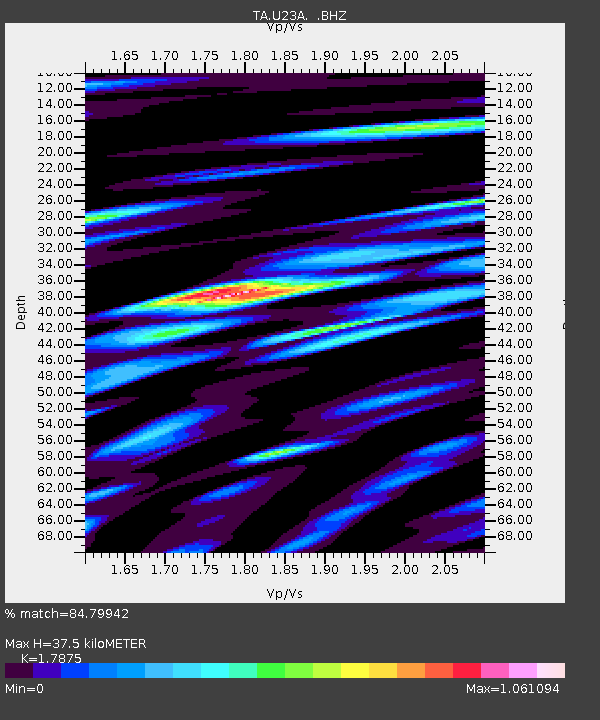
| Estimated Moho Depth: |
37.5 km |
| Estimated Crust Vp/Vs: |
1.79 |
| Assumed Crust Vp: |
6.159 km/s |
| Estimated Crust Vs: |
3.445 km/s |
| Estimated Crust Poisson's Ratio: |
0.27 |
|
| Radial Match: |
84.79942 % |
| Radial Bump: |
400 |
| Transverse Match: |
72.60703 % |
| Transverse Bump: |
400 |
| SOD ConfigId: |
2504 |
| Insert Time: |
2010-03-06 20:58:03.843 +0000 |
| GWidth: |
2.5 |
| Max Bumps: |
400 |
| Tol: |
0.001 |
|

Signal To Noise
| Channel | StoN | STA | LTA |
| TA:U23A: :BHZ:20080719T22:51:17.450Z | 11.504563 | 1.097537E-6 | 9.5400154E-8 |
| TA:U23A: :BHN:20080719T22:51:17.450Z | 2.1948943 | 2.1811326E-7 | 9.937301E-8 |
| TA:U23A: :BHE:20080719T22:51:17.450Z | 4.9108353 | 4.043399E-7 | 8.233628E-8 |
| Arrivals |
| Ps | 4.9 SECOND |
| PpPs | 17 SECOND |
| PsPs/PpSs | 22 SECOND |


