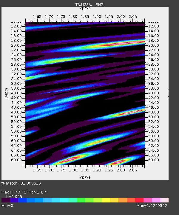
U23A El Rito, NM, USA - Earthquake Result Viewer

Earthquake location: Off East Coast Of Honshu, Japan
Earthquake latitude/longitude: 37.2/142.1
Earthquake time(UTC): 2008/07/21 (203) 11:30:29 GMT
Earthquake Depth: 22 km
Earthquake Magnitude: 5.7 MB, 5.6 MS, 6.0 MW, 5.9 MW
Earthquake Catalog/Contributor: WHDF/NEIC
Network: TA USArray Transportable Network (new EarthScope stations)
Station: U23A El Rito, NM, USA
Lat/Lon: 36.33 N/106.19 W
Elevation: 2093 m
Distance: 83.3 deg
Az: 49.033 deg
Baz: 311.689 deg
Ray Param: 0.046234287
Estimated Moho Depth: 47.75 km
Estimated Crust Vp/Vs: 2.05
Assumed Crust Vp: 6.159 km/s
Estimated Crust Vs: 3.012 km/s
Estimated Crust Poisson's Ratio: 0.34
Radial Match: 81.393616 %
Radial Bump: 400
Transverse Match: 80.87924 %
Transverse Bump: 400
SOD ConfigId: 2504
Insert Time: 2010-03-06 20:58:05.327 +0000
GWidth: 2.5
Max Bumps: 400
Tol: 0.001

Signal To Noise

ChannelStoNSTALTA
TA:U23A: :BHZ:20080721T11:42:23.074006Z3.03961012.6520252E-78.7248864E-8
TA:U23A: :BHN:20080721T11:42:23.074006Z1.16189039.0596856E-87.797368E-8
TA:U23A: :BHE:20080721T11:42:23.074006Z1.9964531.05882734E-75.3035425E-8
Arrivals
Ps8.3 SECOND
PpPs23 SECOND
PsPs/PpSs31 SECOND