You are here: Home > Network List > TA - USArray Transportable Network (new EarthScope stations) Stations List
> Station U23A El Rito, NM, USA > Earthquake Result Viewer
U23A El Rito, NM, USA - Earthquake Result Viewer
| Earthquake location: |
Eastern Honshu, Japan |
| Earthquake latitude/longitude: |
39.8/141.5 |
| Earthquake time(UTC): |
2008/07/23 (205) 15:26:19 GMT |
| Earthquake Depth: |
108 km |
| Earthquake Magnitude: |
6.6 MB, 6.8 MW, 6.8 MW |
| Earthquake Catalog/Contributor: |
WHDF/NEIC |
|
| Network: |
TA USArray Transportable Network (new EarthScope stations) |
| Station: |
U23A El Rito, NM, USA |
| Lat/Lon: |
36.33 N/106.19 W |
| Elevation: |
2093 m |
|
| Distance: |
82.0 deg |
| Az: |
48.962 deg |
| Baz: |
313.981 deg |
| Ray Param: |
0.046968825 |
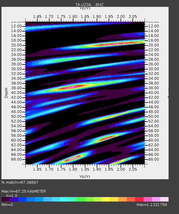
| Estimated Moho Depth: |
67.25 km |
| Estimated Crust Vp/Vs: |
1.80 |
| Assumed Crust Vp: |
6.159 km/s |
| Estimated Crust Vs: |
3.421 km/s |
| Estimated Crust Poisson's Ratio: |
0.28 |
|
| Radial Match: |
97.36887 % |
| Radial Bump: |
400 |
| Transverse Match: |
95.83929 % |
| Transverse Bump: |
400 |
| SOD ConfigId: |
2504 |
| Insert Time: |
2010-03-06 20:58:06.700 +0000 |
| GWidth: |
2.5 |
| Max Bumps: |
400 |
| Tol: |
0.001 |
|

Signal To Noise
| Channel | StoN | STA | LTA |
| TA:U23A: :BHZ:20080723T15:37:56.775012Z | 21.943773 | 3.3641643E-6 | 1.5330838E-7 |
| TA:U23A: :BHN:20080723T15:37:56.775012Z | 7.911114 | 9.12936E-7 | 1.1539917E-7 |
| TA:U23A: :BHE:20080723T15:37:56.775012Z | 5.8993583 | 1.0285767E-6 | 1.74354E-7 |
| Arrivals |
| Ps | 8.9 SECOND |
| PpPs | 30 SECOND |
| PsPs/PpSs | 39 SECOND |


