You are here: Home > Network List > TA - USArray Transportable Network (new EarthScope stations) Stations List
> Station P17K Kvichak River, AK, USA > Earthquake Result Viewer
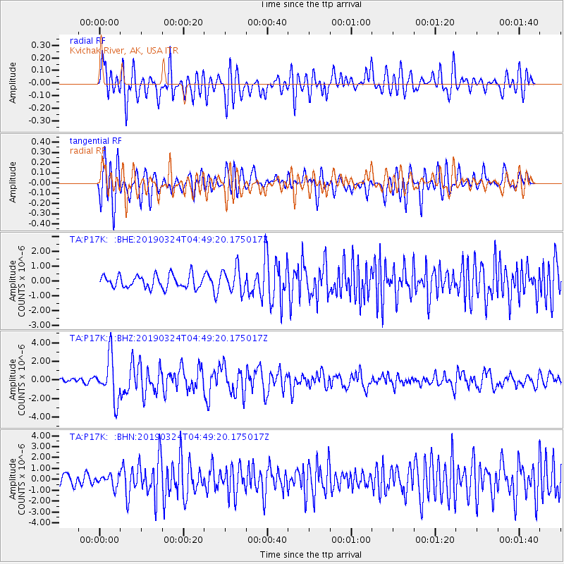
P17K Kvichak River, AK, USA - Earthquake Result Viewer
*The percent match for this event was below the threshold and hence no stack was calculated.
| Earthquake location: |
Northern Molucca Sea |
| Earthquake latitude/longitude: |
1.7/126.4 |
| Earthquake time(UTC): |
2019/03/24 (083) 04:37:34 GMT |
| Earthquake Depth: |
37 km |
| Earthquake Magnitude: |
6.1 Mww |
| Earthquake Catalog/Contributor: |
NEIC PDE/us |
|
| Network: |
TA USArray Transportable Network (new EarthScope stations) |
| Station: |
P17K Kvichak River, AK, USA |
| Lat/Lon: |
59.20 N/156.44 W |
| Elevation: |
91 m |
|
| Distance: |
82.0 deg |
| Az: |
30.446 deg |
| Baz: |
259.788 deg |
| Ray Param: |
$rayparam |
*The percent match for this event was below the threshold and hence was not used in the summary stack. |
|
| Radial Match: |
67.944786 % |
| Radial Bump: |
400 |
| Transverse Match: |
73.175026 % |
| Transverse Bump: |
400 |
| SOD ConfigId: |
13570011 |
| Insert Time: |
2019-05-02 19:24:45.708 +0000 |
| GWidth: |
2.5 |
| Max Bumps: |
400 |
| Tol: |
0.001 |
|
Signal To Noise
| Channel | StoN | STA | LTA |
| TA:P17K: :BHZ:20190324T04:49:20.175017Z | 11.557782 | 2.3587218E-6 | 2.0408083E-7 |
| TA:P17K: :BHN:20190324T04:49:20.175017Z | 0.8322168 | 5.326714E-7 | 6.4006326E-7 |
| TA:P17K: :BHE:20190324T04:49:20.175017Z | 1.9161817 | 8.248485E-7 | 4.3046467E-7 |
| Arrivals |
| Ps | |
| PpPs | |
| PsPs/PpSs | |


