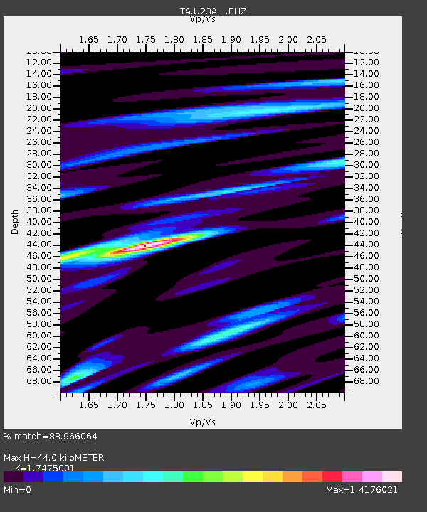
U23A El Rito, NM, USA - Earthquake Result Viewer
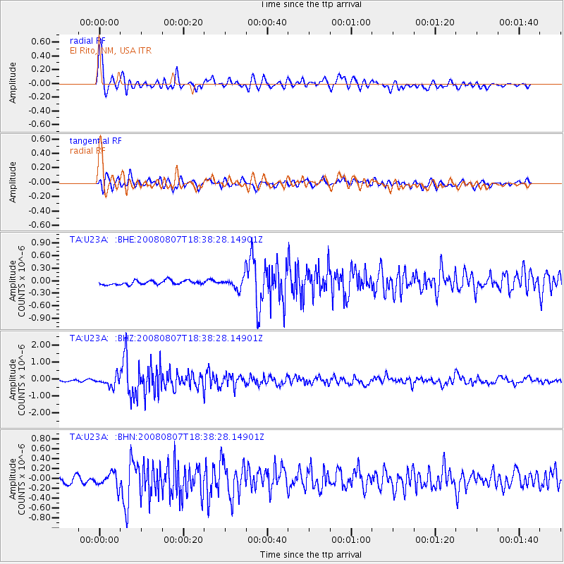
Earthquake location: Andreanof Islands, Aleutian Is.
Earthquake latitude/longitude: 52.2/-175.7
Earthquake time(UTC): 2008/08/07 (220) 18:30:03 GMT
Earthquake Depth: 12 km
Earthquake Magnitude: 5.6 MB, 5.5 MS, 5.8 MW, 5.8 MW
Earthquake Catalog/Contributor: WHDF/NEIC
Network: TA USArray Transportable Network (new EarthScope stations)
Station: U23A El Rito, NM, USA
Lat/Lon: 36.33 N/106.19 W
Elevation: 2093 m
Distance: 50.3 deg
Az: 79.524 deg
Baz: 311.441 deg
Ray Param: 0.068168625
Estimated Moho Depth: 44.0 km
Estimated Crust Vp/Vs: 1.75
Assumed Crust Vp: 6.159 km/s
Estimated Crust Vs: 3.524 km/s
Estimated Crust Poisson's Ratio: 0.26
Radial Match: 88.966064 %
Radial Bump: 400
Transverse Match: 84.97236 %
Transverse Bump: 400
SOD ConfigId: 2504
Insert Time: 2010-03-06 20:58:10.440 +0000
GWidth: 2.5
Max Bumps: 400
Tol: 0.001

Signal To Noise

ChannelStoNSTALTA
TA:U23A: :BHZ:20080807T18:38:28.14901Z7.2660763.082638E-74.242507E-8
TA:U23A: :BHN:20080807T18:38:28.14901Z2.07584741.6350047E-77.876324E-8
TA:U23A: :BHE:20080807T18:38:28.14901Z3.0466911.514697E-74.971614E-8
Arrivals
Ps5.6 SECOND
PpPs19 SECOND
PsPs/PpSs24 SECOND