You are here: Home > Network List > TA - USArray Transportable Network (new EarthScope stations) Stations List
> Station U23A El Rito, NM, USA > Earthquake Result Viewer
U23A El Rito, NM, USA - Earthquake Result Viewer
| Earthquake location: |
North Of Severnaya Zemlya |
| Earthquake latitude/longitude: |
83.6/115.2 |
| Earthquake time(UTC): |
2008/08/13 (226) 08:35:02 GMT |
| Earthquake Depth: |
10 km |
| Earthquake Magnitude: |
5.5 MB, 4.7 MS, 5.4 MW, 5.4 MW |
| Earthquake Catalog/Contributor: |
WHDF/NEIC |
|
| Network: |
TA USArray Transportable Network (new EarthScope stations) |
| Station: |
U23A El Rito, NM, USA |
| Lat/Lon: |
36.33 N/106.19 W |
| Elevation: |
2093 m |
|
| Distance: |
58.8 deg |
| Az: |
38.687 deg |
| Baz: |
355.049 deg |
| Ray Param: |
0.06263615 |
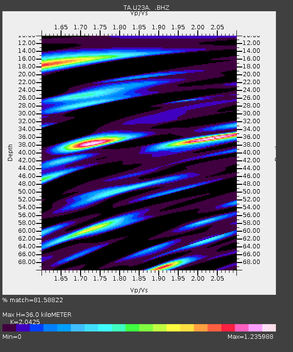
| Estimated Moho Depth: |
36.0 km |
| Estimated Crust Vp/Vs: |
2.04 |
| Assumed Crust Vp: |
6.159 km/s |
| Estimated Crust Vs: |
3.015 km/s |
| Estimated Crust Poisson's Ratio: |
0.34 |
|
| Radial Match: |
81.58822 % |
| Radial Bump: |
400 |
| Transverse Match: |
83.3215 % |
| Transverse Bump: |
400 |
| SOD ConfigId: |
2504 |
| Insert Time: |
2010-03-06 20:58:11.621 +0000 |
| GWidth: |
2.5 |
| Max Bumps: |
400 |
| Tol: |
0.001 |
|
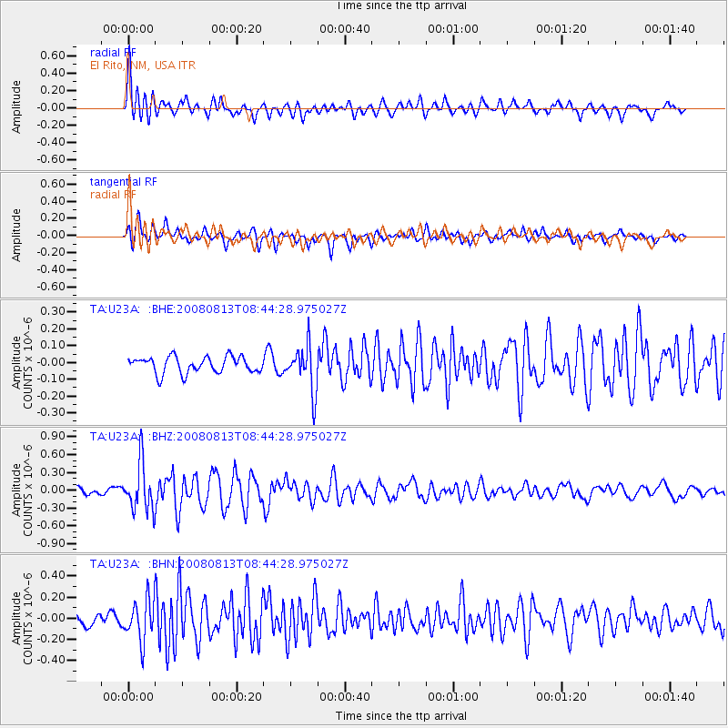
Signal To Noise
| Channel | StoN | STA | LTA |
| TA:U23A: :BHZ:20080813T08:44:28.975027Z | 6.827909 | 4.03964E-7 | 5.916365E-8 |
| TA:U23A: :BHN:20080813T08:44:28.975027Z | 3.3834822 | 1.9523753E-7 | 5.7703136E-8 |
| TA:U23A: :BHE:20080813T08:44:28.975027Z | 2.7694232 | 1.3574898E-7 | 4.9017057E-8 |
| Arrivals |
| Ps | 6.3 SECOND |
| PpPs | 17 SECOND |
| PsPs/PpSs | 23 SECOND |


