You are here: Home > Network List > TS - TERRAscope (Southern California Seismic Network) Stations List
> Station DGR Domenigoni Valley Reservior, California, USA > Earthquake Result Viewer
DGR Domenigoni Valley Reservior, California, USA - Earthquake Result Viewer
| Earthquake location: |
Vanuatu Islands |
| Earthquake latitude/longitude: |
-19.5/169.2 |
| Earthquake time(UTC): |
1995/06/29 (180) 12:24:03 GMT |
| Earthquake Depth: |
144 km |
| Earthquake Magnitude: |
6.2 MB, 6.7 UNKNOWN, 6.6 MW |
| Earthquake Catalog/Contributor: |
WHDF/NEIC |
|
| Network: |
TS TERRAscope (Southern California Seismic Network) |
| Station: |
DGR Domenigoni Valley Reservior, California, USA |
| Lat/Lon: |
33.65 N/117.01 W |
| Elevation: |
700 m |
|
| Distance: |
87.8 deg |
| Az: |
53.263 deg |
| Baz: |
245.025 deg |
| Ray Param: |
0.04270391 |
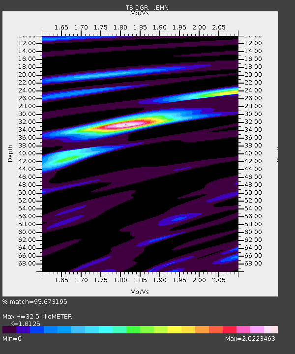
| Estimated Moho Depth: |
32.5 km |
| Estimated Crust Vp/Vs: |
1.81 |
| Assumed Crust Vp: |
6.264 km/s |
| Estimated Crust Vs: |
3.456 km/s |
| Estimated Crust Poisson's Ratio: |
0.28 |
|
| Radial Match: |
95.673195 % |
| Radial Bump: |
400 |
| Transverse Match: |
86.34419 % |
| Transverse Bump: |
400 |
| SOD ConfigId: |
6273 |
| Insert Time: |
2010-02-26 14:08:34.837 +0000 |
| GWidth: |
2.5 |
| Max Bumps: |
400 |
| Tol: |
0.001 |
|
Signal To Noise
| Channel | StoN | STA | LTA |
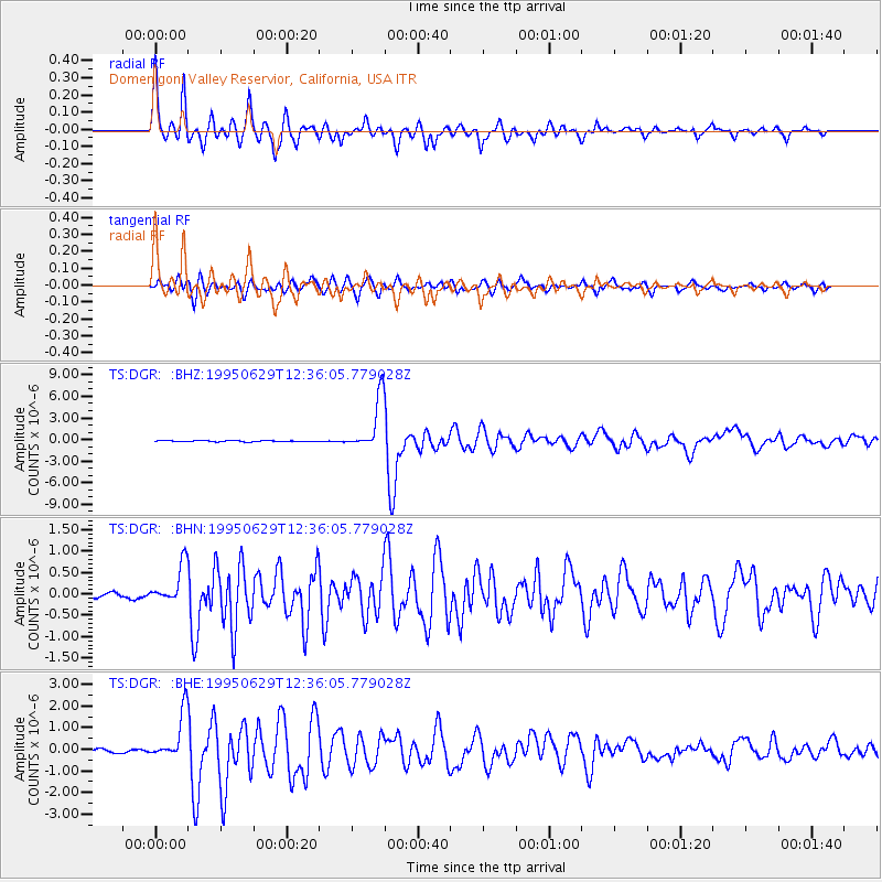
| TS:DGR: :BHN:19950629T12:36:05.779028Z | 6.8618016 | 4.553034E-7 | 6.635333E-8 |
| TS:DGR: :BHE:19950629T12:36:05.779028Z | 15.304431 | 1.0872548E-6 | 7.1041825E-8 |
| TS:DGR: :BHZ:19950629T12:36:05.779028Z | 52.58862 | 3.6601757E-6 | 6.960015E-8 |
| Arrivals |
| Ps | 4.3 SECOND |
| PpPs | 14 SECOND |
| PsPs/PpSs | 19 SECOND |


