You are here: Home > Network List > TA - USArray Transportable Network (new EarthScope stations) Stations List
> Station U23A El Rito, NM, USA > Earthquake Result Viewer
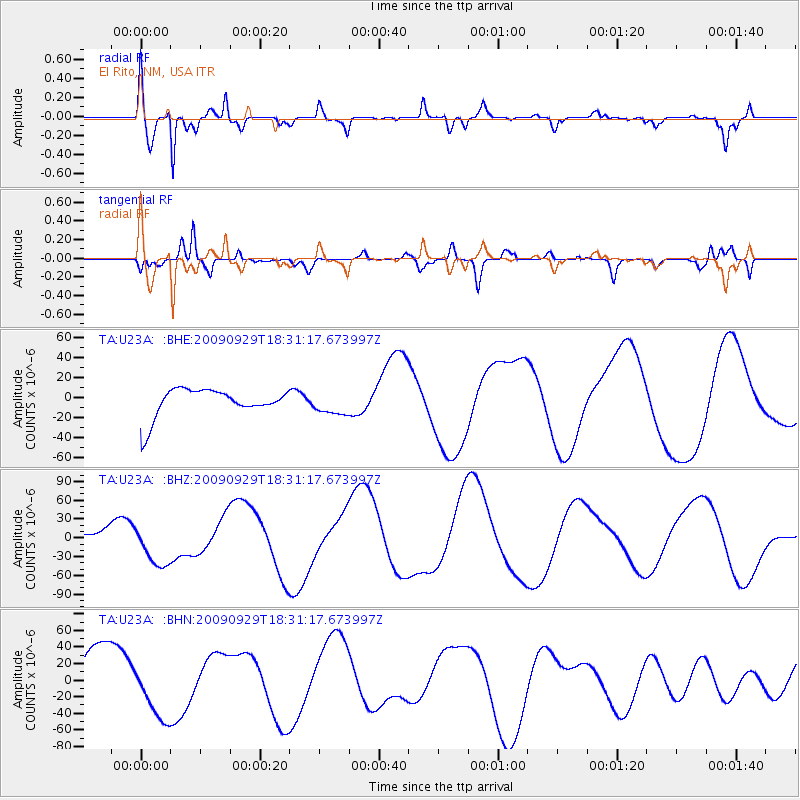
U23A El Rito, NM, USA - Earthquake Result Viewer
| Earthquake location: |
Samoa Islands Region |
| Earthquake latitude/longitude: |
-15.9/-171.7 |
| Earthquake time(UTC): |
2009/09/29 (272) 18:19:35 GMT |
| Earthquake Depth: |
10 km |
| Earthquake Magnitude: |
5.6 MB |
| Earthquake Catalog/Contributor: |
WHDF/NEIC |
|
| Network: |
TA USArray Transportable Network (new EarthScope stations) |
| Station: |
U23A El Rito, NM, USA |
| Lat/Lon: |
36.33 N/106.19 W |
| Elevation: |
2093 m |
|
| Distance: |
80.7 deg |
| Az: |
48.109 deg |
| Baz: |
242.479 deg |
| Ray Param: |
0.048096363 |
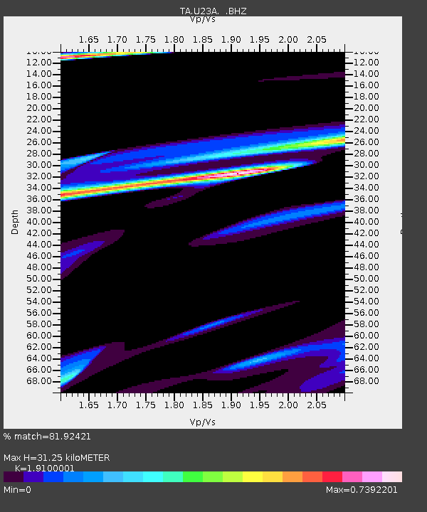
| Estimated Moho Depth: |
31.25 km |
| Estimated Crust Vp/Vs: |
1.91 |
| Assumed Crust Vp: |
6.159 km/s |
| Estimated Crust Vs: |
3.224 km/s |
| Estimated Crust Poisson's Ratio: |
0.31 |
|
| Radial Match: |
81.92421 % |
| Radial Bump: |
400 |
| Transverse Match: |
66.71141 % |
| Transverse Bump: |
400 |
| SOD ConfigId: |
2622 |
| Insert Time: |
2010-03-06 20:58:46.104 +0000 |
| GWidth: |
2.5 |
| Max Bumps: |
400 |
| Tol: |
0.001 |
|
Signal To Noise
| Channel | StoN | STA | LTA |
| TA:U23A: :BHZ:20090929T18:31:17.673997Z | 1.6882697 | 3.7775895E-5 | 2.237551E-5 |
| TA:U23A: :BHN:20090929T18:31:17.673997Z | 1.1579415 | 3.5698147E-5 | 3.0828975E-5 |
| TA:U23A: :BHE:20090929T18:31:17.673997Z | 0.8135442 | 1.1451527E-5 | 1.4076097E-5 |
| Arrivals |
| Ps | 4.7 SECOND |
| PpPs | 14 SECOND |
| PsPs/PpSs | 19 SECOND |


