You are here: Home > Network List > TA - USArray Transportable Network (new EarthScope stations) Stations List
> Station U23A El Rito, NM, USA > Earthquake Result Viewer
U23A El Rito, NM, USA - Earthquake Result Viewer
| Earthquake location: |
Northern Mid-Atlantic Ridge |
| Earthquake latitude/longitude: |
23.9/-46.1 |
| Earthquake time(UTC): |
2009/06/06 (157) 20:33:28 GMT |
| Earthquake Depth: |
14 km |
| Earthquake Magnitude: |
6.0 MB, 5.7 MS, 6.0 MW, 6.0 MW |
| Earthquake Catalog/Contributor: |
WHDF/NEIC |
|
| Network: |
TA USArray Transportable Network (new EarthScope stations) |
| Station: |
U23A El Rito, NM, USA |
| Lat/Lon: |
36.33 N/106.19 W |
| Elevation: |
2093 m |
|
| Distance: |
52.7 deg |
| Az: |
298.371 deg |
| Baz: |
85.994 deg |
| Ray Param: |
0.06658113 |
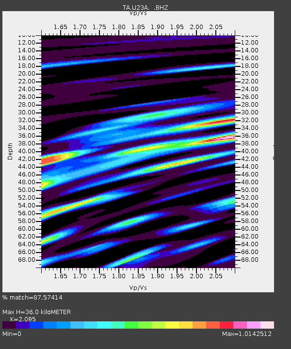
| Estimated Moho Depth: |
36.0 km |
| Estimated Crust Vp/Vs: |
2.10 |
| Assumed Crust Vp: |
6.159 km/s |
| Estimated Crust Vs: |
2.94 km/s |
| Estimated Crust Poisson's Ratio: |
0.35 |
|
| Radial Match: |
87.57414 % |
| Radial Bump: |
400 |
| Transverse Match: |
78.04385 % |
| Transverse Bump: |
400 |
| SOD ConfigId: |
2648 |
| Insert Time: |
2010-03-06 20:58:59.214 +0000 |
| GWidth: |
2.5 |
| Max Bumps: |
400 |
| Tol: |
0.001 |
|

Signal To Noise
| Channel | StoN | STA | LTA |
| TA:U23A: :BHZ:20090606T20:42:11.775007Z | 3.981713 | 2.1547531E-7 | 5.4116235E-8 |
| TA:U23A: :BHN:20090606T20:42:11.775007Z | 1.2648098 | 1.09481206E-7 | 8.6559425E-8 |
| TA:U23A: :BHE:20090606T20:42:11.775007Z | 2.0335426 | 2.1779336E-7 | 1.07100455E-7 |
| Arrivals |
| Ps | 6.7 SECOND |
| PpPs | 17 SECOND |
| PsPs/PpSs | 24 SECOND |


