You are here: Home > Network List > TS - TERRAscope (Southern California Seismic Network) Stations List
> Station DGR Domenigoni Valley Reservior, California, USA > Earthquake Result Viewer
DGR Domenigoni Valley Reservior, California, USA - Earthquake Result Viewer
| Earthquake location: |
New Britain Region, P.N.G. |
| Earthquake latitude/longitude: |
-4.8/151.5 |
| Earthquake time(UTC): |
1995/08/14 (226) 04:37:17 GMT |
| Earthquake Depth: |
126 km |
| Earthquake Magnitude: |
6.3 MB, 6.3 MS, 6.4 UNKNOWN |
| Earthquake Catalog/Contributor: |
WHDF/NEIC |
|
| Network: |
TS TERRAscope (Southern California Seismic Network) |
| Station: |
DGR Domenigoni Valley Reservior, California, USA |
| Lat/Lon: |
33.65 N/117.01 W |
| Elevation: |
700 m |
|
| Distance: |
93.9 deg |
| Az: |
56.697 deg |
| Baz: |
266.812 deg |
| Ray Param: |
0.041091662 |
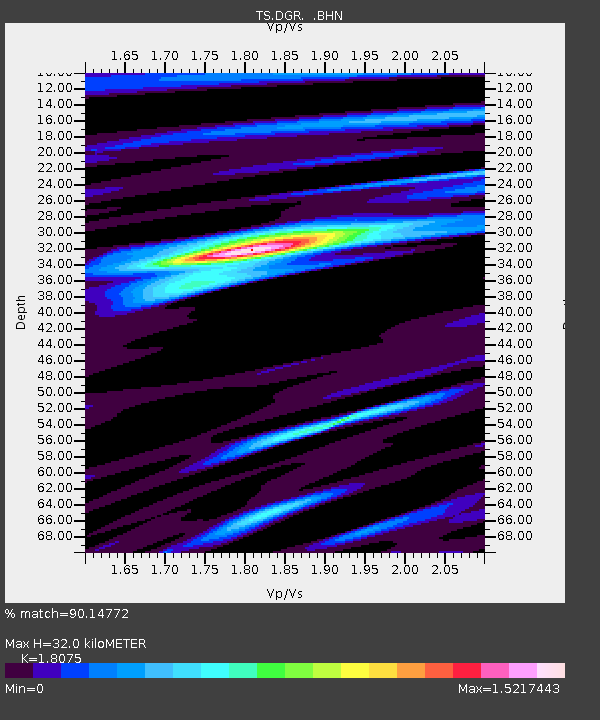
| Estimated Moho Depth: |
32.0 km |
| Estimated Crust Vp/Vs: |
1.81 |
| Assumed Crust Vp: |
6.264 km/s |
| Estimated Crust Vs: |
3.465 km/s |
| Estimated Crust Poisson's Ratio: |
0.28 |
|
| Radial Match: |
90.14772 % |
| Radial Bump: |
400 |
| Transverse Match: |
62.728794 % |
| Transverse Bump: |
400 |
| SOD ConfigId: |
6273 |
| Insert Time: |
2010-02-26 14:08:38.623 +0000 |
| GWidth: |
2.5 |
| Max Bumps: |
400 |
| Tol: |
0.001 |
|
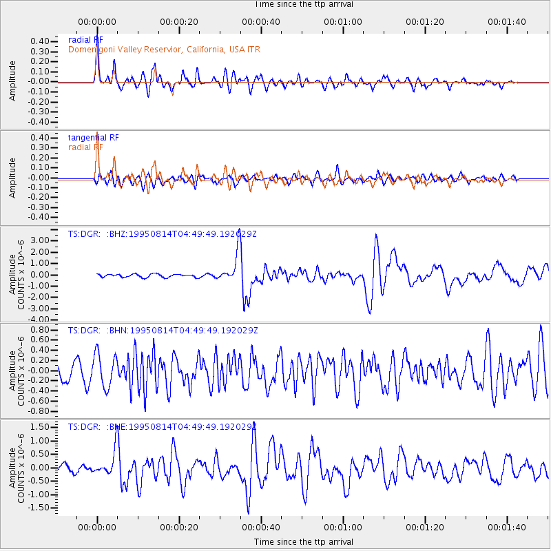
Signal To Noise
| Channel | StoN | STA | LTA |
| TS:DGR: :BHN:19950814T04:49:49.192029Z | 2.5724826 | 3.3712013E-7 | 1.3104855E-7 |
| TS:DGR: :BHE:19950814T04:49:49.192029Z | 3.4657516 | 5.017977E-7 | 1.4478755E-7 |
| TS:DGR: :BHZ:19950814T04:49:49.192029Z | 10.075118 | 1.404809E-6 | 1.3943351E-7 |
| Arrivals |
| Ps | 4.2 SECOND |
| PpPs | 14 SECOND |
| PsPs/PpSs | 18 SECOND |


