You are here: Home > Network List > TA - USArray Transportable Network (new EarthScope stations) Stations List
> Station U23A El Rito, NM, USA > Earthquake Result Viewer
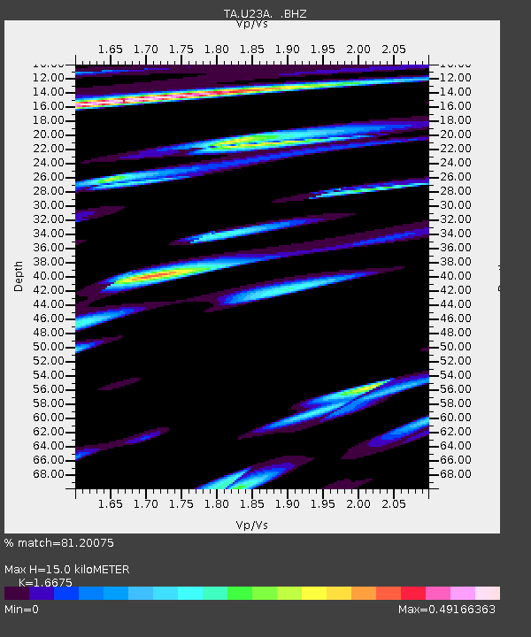
U23A El Rito, NM, USA - Earthquake Result Viewer
| Earthquake location: |
Near Coast Of Central Chile |
| Earthquake latitude/longitude: |
-32.5/-71.7 |
| Earthquake time(UTC): |
2008/12/18 (353) 21:19:28 GMT |
| Earthquake Depth: |
18 km |
| Earthquake Magnitude: |
5.8 MB, 6.0 MS, 6.2 MW, 6.1 MW |
| Earthquake Catalog/Contributor: |
WHDF/NEIC |
|
| Network: |
TA USArray Transportable Network (new EarthScope stations) |
| Station: |
U23A El Rito, NM, USA |
| Lat/Lon: |
36.33 N/106.19 W |
| Elevation: |
2093 m |
|
| Distance: |
75.7 deg |
| Az: |
331.855 deg |
| Baz: |
150.407 deg |
| Ray Param: |
0.051509216 |
| Estimated Moho Depth: |
15.0 km |
| Estimated Crust Vp/Vs: |
1.67 |
| Assumed Crust Vp: |
6.159 km/s |
| Estimated Crust Vs: |
3.693 km/s |
| Estimated Crust Poisson's Ratio: |
0.22 |
|
| Radial Match: |
81.20075 % |
| Radial Bump: |
400 |
| Transverse Match: |
65.98376 % |
| Transverse Bump: |
400 |
| SOD ConfigId: |
2658 |
| Insert Time: |
2010-03-06 20:59:08.097 +0000 |
| GWidth: |
2.5 |
| Max Bumps: |
400 |
| Tol: |
0.001 |
|

Signal To Noise
| Channel | StoN | STA | LTA |
| TA:U23A: :BHZ:20081218T21:30:41.02502Z | 3.3735301 | 3.6169936E-7 | 1.0721688E-7 |
| TA:U23A: :BHN:20081218T21:30:41.02502Z | 1.0455332 | 1.2003585E-7 | 1.14808266E-7 |
| TA:U23A: :BHE:20081218T21:30:41.02502Z | 1.9123968 | 1.7916133E-7 | 9.3684186E-8 |
| Arrivals |
| Ps | 1.7 SECOND |
| PpPs | 6.3 SECOND |
| PsPs/PpSs | 8.0 SECOND |


