You are here: Home > Network List > TA - USArray Transportable Network (new EarthScope stations) Stations List
> Station E20K Nigu River, AK, USA > Earthquake Result Viewer
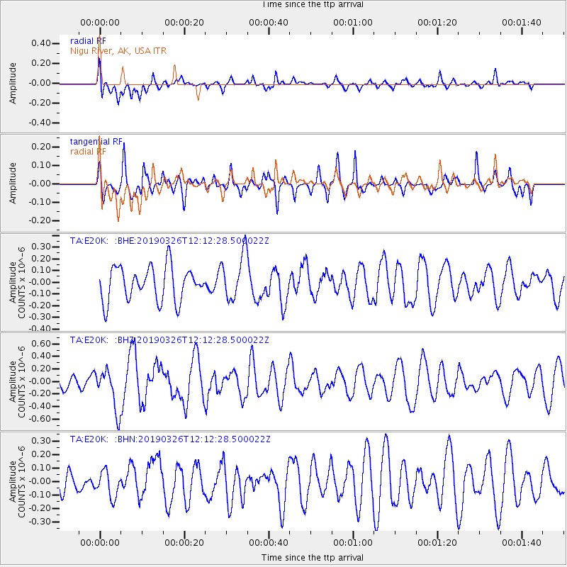
E20K Nigu River, AK, USA - Earthquake Result Viewer
*The percent match for this event was below the threshold and hence no stack was calculated.
| Earthquake location: |
Off Coast Of Central America |
| Earthquake latitude/longitude: |
12.5/-89.2 |
| Earthquake time(UTC): |
2019/03/26 (085) 12:01:48 GMT |
| Earthquake Depth: |
10 km |
| Earthquake Magnitude: |
5.6 Mww |
| Earthquake Catalog/Contributor: |
NEIC PDE/us |
|
| Network: |
TA USArray Transportable Network (new EarthScope stations) |
| Station: |
E20K Nigu River, AK, USA |
| Lat/Lon: |
68.26 N/156.19 W |
| Elevation: |
866 m |
|
| Distance: |
70.0 deg |
| Az: |
338.602 deg |
| Baz: |
106.995 deg |
| Ray Param: |
$rayparam |
*The percent match for this event was below the threshold and hence was not used in the summary stack. |
|
| Radial Match: |
45.0952 % |
| Radial Bump: |
400 |
| Transverse Match: |
62.399418 % |
| Transverse Bump: |
335 |
| SOD ConfigId: |
13570011 |
| Insert Time: |
2019-05-02 19:31:50.442 +0000 |
| GWidth: |
2.5 |
| Max Bumps: |
400 |
| Tol: |
0.001 |
|
Signal To Noise
| Channel | StoN | STA | LTA |
| TA:E20K: :BHZ:20190326T12:12:28.500022Z | 3.3682833 | 3.3837426E-7 | 1.0045897E-7 |
| TA:E20K: :BHN:20190326T12:12:28.500022Z | 1.1325122 | 9.858843E-8 | 8.705286E-8 |
| TA:E20K: :BHE:20190326T12:12:28.500022Z | 1.367016 | 1.9739237E-7 | 1.4439654E-7 |
| Arrivals |
| Ps | |
| PpPs | |
| PsPs/PpSs | |


