You are here: Home > Network List > TA - USArray Transportable Network (new EarthScope stations) Stations List
> Station U23A El Rito, NM, USA > Earthquake Result Viewer
U23A El Rito, NM, USA - Earthquake Result Viewer
| Earthquake location: |
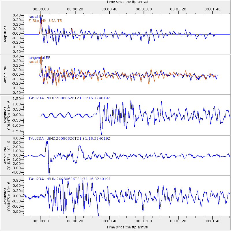
Tonga Islands |
| Earthquake latitude/longitude: |
-20.8/-173.3 |
| Earthquake time(UTC): |
2008/06/26 (178) 21:19:15 GMT |
| Earthquake Depth: |
38 km |
| Earthquake Magnitude: |
6.0 MB, 5.8 MS, 6.2 MW, 6.1 MW |
| Earthquake Catalog/Contributor: |
WHDF/NEIC |
|
| Network: |
TA USArray Transportable Network (new EarthScope stations) |
| Station: |
U23A El Rito, NM, USA |
| Lat/Lon: |
36.33 N/106.19 W |
| Elevation: |
2093 m |
|
| Distance: |
85.1 deg |
| Az: |
48.322 deg |
| Baz: |
239.945 deg |
| Ray Param: |
0.044956658 |
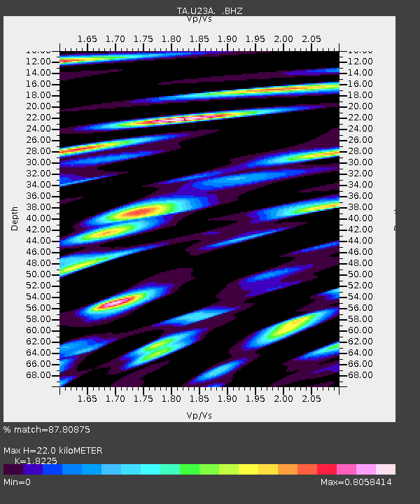
| Estimated Moho Depth: |
22.0 km |
| Estimated Crust Vp/Vs: |
1.82 |
| Assumed Crust Vp: |
6.159 km/s |
| Estimated Crust Vs: |
3.379 km/s |
| Estimated Crust Poisson's Ratio: |
0.28 |
|
| Radial Match: |
87.80875 % |
| Radial Bump: |
400 |
| Transverse Match: |
81.5334 % |
| Transverse Bump: |
400 |
| SOD ConfigId: |
2504 |
| Insert Time: |
2010-03-06 20:59:23.950 +0000 |
| GWidth: |
2.5 |
| Max Bumps: |
400 |
| Tol: |
0.001 |
|
Signal To Noise
| Channel | StoN | STA | LTA |
| TA:U23A: :BHZ:20080626T21:31:16.324019Z | 11.04276 | 1.8026675E-6 | 1.632443E-7 |
| TA:U23A: :BHN:20080626T21:31:16.324019Z | 2.4955075 | 2.4698653E-7 | 9.8972464E-8 |
| TA:U23A: :BHE:20080626T21:31:16.324019Z | 3.8697653 | 5.253523E-7 | 1.3575817E-7 |
| Arrivals |
| Ps | 3.0 SECOND |
| PpPs | 9.9 SECOND |
| PsPs/PpSs | 13 SECOND |


