You are here: Home > Network List > TA - USArray Transportable Network (new EarthScope stations) Stations List
> Station U23A El Rito, NM, USA > Earthquake Result Viewer
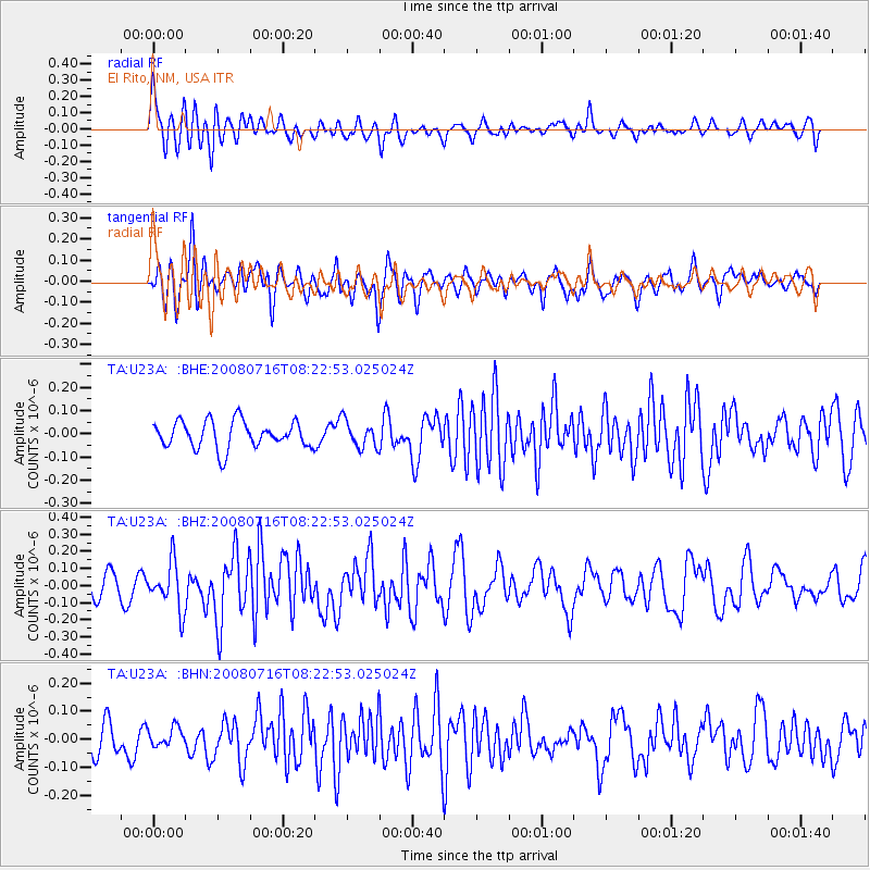
U23A El Rito, NM, USA - Earthquake Result Viewer
*The percent match for this event was below the threshold and hence no stack was calculated.
| Earthquake location: |
Samoa Islands Region |
| Earthquake latitude/longitude: |
-16.6/-173.0 |
| Earthquake time(UTC): |
2008/07/16 (198) 08:11:04 GMT |
| Earthquake Depth: |
10 km |
| Earthquake Magnitude: |
5.5 MB, 5.4 MS, 5.7 MW, 5.7 MW |
| Earthquake Catalog/Contributor: |
WHDF/NEIC |
|
| Network: |
TA USArray Transportable Network (new EarthScope stations) |
| Station: |
U23A El Rito, NM, USA |
| Lat/Lon: |
36.33 N/106.19 W |
| Elevation: |
2093 m |
|
| Distance: |
82.1 deg |
| Az: |
48.523 deg |
| Baz: |
242.826 deg |
| Ray Param: |
$rayparam |
*The percent match for this event was below the threshold and hence was not used in the summary stack. |
|
| Radial Match: |
64.51183 % |
| Radial Bump: |
400 |
| Transverse Match: |
67.0117 % |
| Transverse Bump: |
400 |
| SOD ConfigId: |
2504 |
| Insert Time: |
2010-03-06 20:59:40.904 +0000 |
| GWidth: |
2.5 |
| Max Bumps: |
400 |
| Tol: |
0.001 |
|
Signal To Noise
| Channel | StoN | STA | LTA |
| TA:U23A: :BHZ:20080716T08:22:53.025024Z | 1.6616524 | 1.3540769E-7 | 8.148978E-8 |
| TA:U23A: :BHN:20080716T08:22:53.025024Z | 0.61850107 | 3.2738892E-8 | 5.2932638E-8 |
| TA:U23A: :BHE:20080716T08:22:53.025024Z | 0.99332446 | 5.7610013E-8 | 5.7997173E-8 |
| Arrivals |
| Ps | |
| PpPs | |
| PsPs/PpSs | |


