You are here: Home > Network List > TS - TERRAscope (Southern California Seismic Network) Stations List
> Station DGR Domenigoni Valley Reservior, California, USA > Earthquake Result Viewer
DGR Domenigoni Valley Reservior, California, USA - Earthquake Result Viewer
| Earthquake location: |
South Of Fiji Islands |
| Earthquake latitude/longitude: |
-25.6/-177.5 |
| Earthquake time(UTC): |
1995/10/14 (287) 08:00:41 GMT |
| Earthquake Depth: |
70 km |
| Earthquake Magnitude: |
5.9 MB, 6.2 UNKNOWN, 6.2 MW |
| Earthquake Catalog/Contributor: |
WHDF/NEIC |
|
| Network: |
TS TERRAscope (Southern California Seismic Network) |
| Station: |
DGR Domenigoni Valley Reservior, California, USA |
| Lat/Lon: |
33.65 N/117.01 W |
| Elevation: |
700 m |
|
| Distance: |
82.3 deg |
| Az: |
47.108 deg |
| Baz: |
232.493 deg |
| Ray Param: |
0.046855997 |
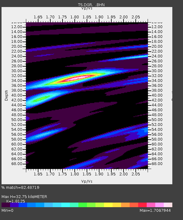
| Estimated Moho Depth: |
32.75 km |
| Estimated Crust Vp/Vs: |
1.81 |
| Assumed Crust Vp: |
6.264 km/s |
| Estimated Crust Vs: |
3.456 km/s |
| Estimated Crust Poisson's Ratio: |
0.28 |
|
| Radial Match: |
82.48719 % |
| Radial Bump: |
326 |
| Transverse Match: |
46.984 % |
| Transverse Bump: |
378 |
| SOD ConfigId: |
6273 |
| Insert Time: |
2010-02-26 14:08:45.487 +0000 |
| GWidth: |
2.5 |
| Max Bumps: |
400 |
| Tol: |
0.001 |
|
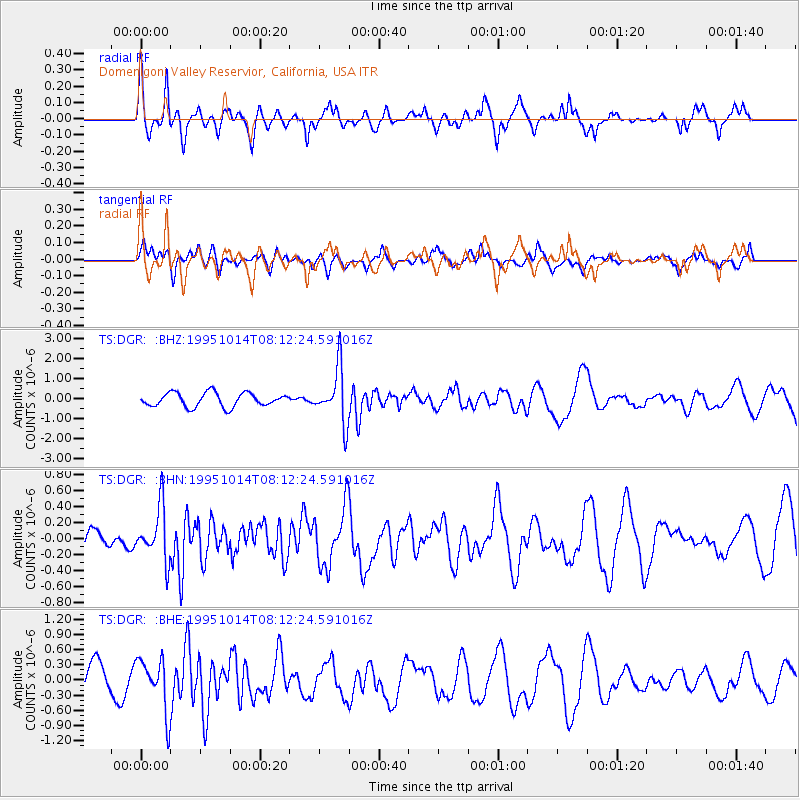
Signal To Noise
| Channel | StoN | STA | LTA |
| TS:DGR: :BHN:19951014T08:12:24.591016Z | 1.6682401 | 3.304863E-7 | 1.9810477E-7 |
| TS:DGR: :BHE:19951014T08:12:24.591016Z | 1.6024998 | 5.289641E-7 | 3.3008683E-7 |
| TS:DGR: :BHZ:19951014T08:12:24.591016Z | 3.924406 | 1.3528423E-6 | 3.4472538E-7 |
| Arrivals |
| Ps | 4.4 SECOND |
| PpPs | 14 SECOND |
| PsPs/PpSs | 19 SECOND |


