You are here: Home > Network List > TA - USArray Transportable Network (new EarthScope stations) Stations List
> Station U23A El Rito, NM, USA > Earthquake Result Viewer
U23A El Rito, NM, USA - Earthquake Result Viewer
*The percent match for this event was below the threshold and hence no stack was calculated.
| Earthquake location: |
Mariana Islands |
| Earthquake latitude/longitude: |
19.1/145.8 |
| Earthquake time(UTC): |
2008/12/02 (337) 12:31:43 GMT |
| Earthquake Depth: |
137 km |
| Earthquake Magnitude: |
5.9 MB, 5.9 MW, 5.9 MW |
| Earthquake Catalog/Contributor: |
WHDF/NEIC |
|
| Network: |
TA USArray Transportable Network (new EarthScope stations) |
| Station: |
U23A El Rito, NM, USA |
| Lat/Lon: |
36.33 N/106.19 W |
| Elevation: |
2093 m |
|
| Distance: |
92.6 deg |
| Az: |
50.221 deg |
| Baz: |
295.854 deg |
| Ray Param: |
$rayparam |
*The percent match for this event was below the threshold and hence was not used in the summary stack. |
|
| Radial Match: |
66.45172 % |
| Radial Bump: |
400 |
| Transverse Match: |
54.333153 % |
| Transverse Bump: |
354 |
| SOD ConfigId: |
2658 |
| Insert Time: |
2010-03-06 21:00:15.612 +0000 |
| GWidth: |
2.5 |
| Max Bumps: |
400 |
| Tol: |
0.001 |
|
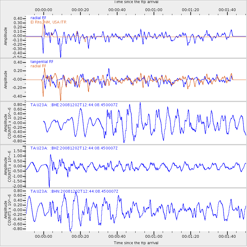
Signal To Noise
| Channel | StoN | STA | LTA |
| TA:U23A: :BHZ:20081202T12:44:08.450007Z | 2.6134243 | 6.7883707E-7 | 2.5975004E-7 |
| TA:U23A: :BHN:20081202T12:44:08.450007Z | 0.6943909 | 1.9292733E-7 | 2.778368E-7 |
| TA:U23A: :BHE:20081202T12:44:08.450007Z | 1.1441163 | 3.1017498E-7 | 2.7110443E-7 |
| Arrivals |
| Ps | |
| PpPs | |
| PsPs/PpSs | |


