You are here: Home > Network List > TA - USArray Transportable Network (new EarthScope stations) Stations List
> Station U23A El Rito, NM, USA > Earthquake Result Viewer
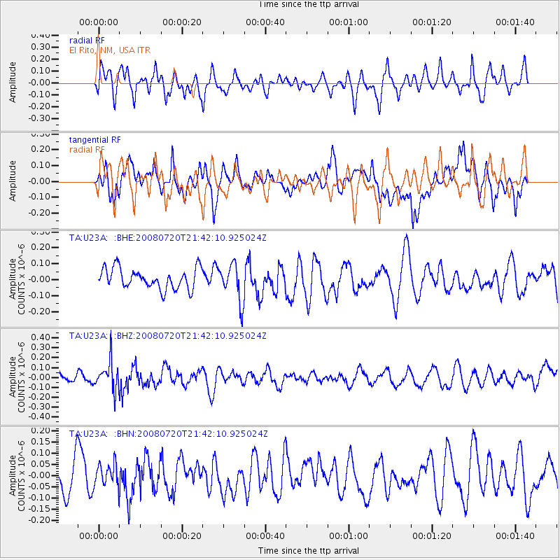
U23A El Rito, NM, USA - Earthquake Result Viewer
*The percent match for this event was below the threshold and hence no stack was calculated.
| Earthquake location: |
Bonin Islands, Japan Region |
| Earthquake latitude/longitude: |
27.8/139.6 |
| Earthquake time(UTC): |
2008/07/20 (202) 21:30:29 GMT |
| Earthquake Depth: |
481 km |
| Earthquake Magnitude: |
5.8 MW, 5.1 MB, 5.8 MW |
| Earthquake Catalog/Contributor: |
WHDF/NEIC |
|
| Network: |
TA USArray Transportable Network (new EarthScope stations) |
| Station: |
U23A El Rito, NM, USA |
| Lat/Lon: |
36.33 N/106.19 W |
| Elevation: |
2093 m |
|
| Distance: |
91.1 deg |
| Az: |
47.455 deg |
| Baz: |
306.058 deg |
| Ray Param: |
$rayparam |
*The percent match for this event was below the threshold and hence was not used in the summary stack. |
|
| Radial Match: |
52.202953 % |
| Radial Bump: |
400 |
| Transverse Match: |
66.65123 % |
| Transverse Bump: |
400 |
| SOD ConfigId: |
2504 |
| Insert Time: |
2010-03-06 21:00:34.262 +0000 |
| GWidth: |
2.5 |
| Max Bumps: |
400 |
| Tol: |
0.001 |
|
Signal To Noise
| Channel | StoN | STA | LTA |
| TA:U23A: :BHZ:20080720T21:42:10.925024Z | 1.5961071 | 1.4645248E-7 | 9.1756036E-8 |
| TA:U23A: :BHN:20080720T21:42:10.925024Z | 0.50643164 | 4.9729717E-8 | 9.819631E-8 |
| TA:U23A: :BHE:20080720T21:42:10.925024Z | 1.8650141 | 1.1864815E-7 | 6.361783E-8 |
| Arrivals |
| Ps | |
| PpPs | |
| PsPs/PpSs | |


