You are here: Home > Network List > AK - Alaska Regional Network Stations List
> Station BARK Barkley Ridge, AK, USA > Earthquake Result Viewer
BARK Barkley Ridge, AK, USA - Earthquake Result Viewer
| Earthquake location: |
East Of Kuril Islands |
| Earthquake latitude/longitude: |
50.5/160.0 |
| Earthquake time(UTC): |
2019/03/28 (087) 22:06:49 GMT |
| Earthquake Depth: |
9.0 km |
| Earthquake Magnitude: |
6.2 Mww |
| Earthquake Catalog/Contributor: |
NEIC PDE/us |
|
| Network: |
AK Alaska Regional Network |
| Station: |
BARK Barkley Ridge, AK, USA |
| Lat/Lon: |
60.40 N/142.49 W |
| Elevation: |
1390 m |
|
| Distance: |
33.1 deg |
| Az: |
50.171 deg |
| Baz: |
278.913 deg |
| Ray Param: |
0.07838736 |
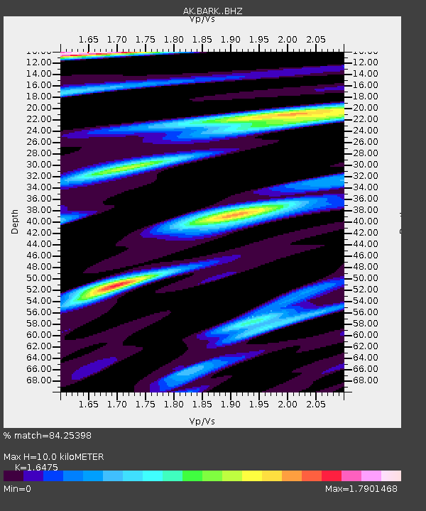
| Estimated Moho Depth: |
10.0 km |
| Estimated Crust Vp/Vs: |
1.65 |
| Assumed Crust Vp: |
6.566 km/s |
| Estimated Crust Vs: |
3.986 km/s |
| Estimated Crust Poisson's Ratio: |
0.21 |
|
| Radial Match: |
84.25398 % |
| Radial Bump: |
400 |
| Transverse Match: |
75.11994 % |
| Transverse Bump: |
400 |
| SOD ConfigId: |
13570011 |
| Insert Time: |
2019-05-02 19:49:01.359 +0000 |
| GWidth: |
2.5 |
| Max Bumps: |
400 |
| Tol: |
0.001 |
|

Signal To Noise
| Channel | StoN | STA | LTA |
| AK:BARK: :BHZ:20190328T22:12:54.407996Z | 28.6587 | 5.590585E-6 | 1.950746E-7 |
| AK:BARK: :BHN:20190328T22:12:54.407996Z | 4.785796 | 1.0024908E-6 | 2.094721E-7 |
| AK:BARK: :BHE:20190328T22:12:54.407996Z | 19.490837 | 3.2064158E-6 | 1.6450888E-7 |
| Arrivals |
| Ps | 1.1 SECOND |
| PpPs | 3.7 SECOND |
| PsPs/PpSs | 4.8 SECOND |


