You are here: Home > Network List > AK - Alaska Regional Network Stations List
> Station MESA Mesa, AK, USA > Earthquake Result Viewer
MESA Mesa, AK, USA - Earthquake Result Viewer
| Earthquake location: |
East Of Kuril Islands |
| Earthquake latitude/longitude: |
50.5/160.0 |
| Earthquake time(UTC): |
2019/03/28 (087) 22:06:49 GMT |
| Earthquake Depth: |
9.0 km |
| Earthquake Magnitude: |
6.2 Mww |
| Earthquake Catalog/Contributor: |
NEIC PDE/us |
|
| Network: |
AK Alaska Regional Network |
| Station: |
MESA Mesa, AK, USA |
| Lat/Lon: |
60.18 N/141.95 W |
| Elevation: |
1907 m |
|
| Distance: |
33.4 deg |
| Az: |
50.498 deg |
| Baz: |
279.658 deg |
| Ray Param: |
0.078246795 |
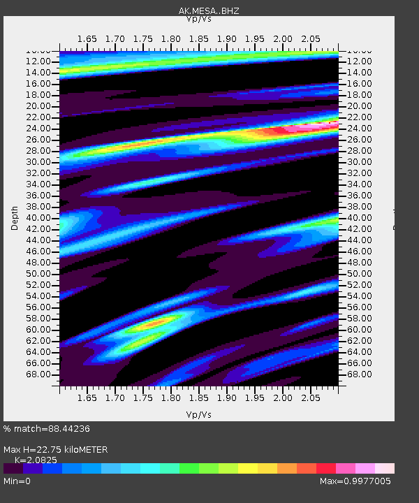
| Estimated Moho Depth: |
22.75 km |
| Estimated Crust Vp/Vs: |
2.08 |
| Assumed Crust Vp: |
6.566 km/s |
| Estimated Crust Vs: |
3.153 km/s |
| Estimated Crust Poisson's Ratio: |
0.35 |
|
| Radial Match: |
88.44236 % |
| Radial Bump: |
368 |
| Transverse Match: |
75.62908 % |
| Transverse Bump: |
400 |
| SOD ConfigId: |
13570011 |
| Insert Time: |
2019-05-02 19:49:17.736 +0000 |
| GWidth: |
2.5 |
| Max Bumps: |
400 |
| Tol: |
0.001 |
|

Signal To Noise
| Channel | StoN | STA | LTA |
| AK:MESA: :BHZ:20190328T22:12:57.04801Z | 15.913236 | 5.095203E-6 | 3.201865E-7 |
| AK:MESA: :BHN:20190328T22:12:57.04801Z | 3.25479 | 1.017994E-6 | 3.1276792E-7 |
| AK:MESA: :BHE:20190328T22:12:57.04801Z | 7.7627068 | 2.758354E-6 | 3.5533404E-7 |
| Arrivals |
| Ps | 4.0 SECOND |
| PpPs | 10.0 SECOND |
| PsPs/PpSs | 14 SECOND |


