You are here: Home > Network List > CI - Caltech Regional Seismic Network Stations List
> Station ADO Adelanto Receiving Station, Victorville, CA, USA > Earthquake Result Viewer
ADO Adelanto Receiving Station, Victorville, CA, USA - Earthquake Result Viewer
| Earthquake location: |
East Of Kuril Islands |
| Earthquake latitude/longitude: |
50.5/160.0 |
| Earthquake time(UTC): |
2019/03/28 (087) 22:06:49 GMT |
| Earthquake Depth: |
9.0 km |
| Earthquake Magnitude: |
6.2 Mww |
| Earthquake Catalog/Contributor: |
NEIC PDE/us |
|
| Network: |
CI Caltech Regional Seismic Network |
| Station: |
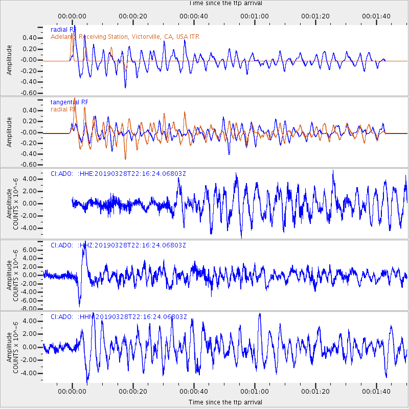
ADO Adelanto Receiving Station, Victorville, CA, USA |
| Lat/Lon: |
34.55 N/117.43 W |
| Elevation: |
908 m |
|
| Distance: |
59.8 deg |
| Az: |
71.195 deg |
| Baz: |
312.914 deg |
| Ray Param: |
0.06192216 |
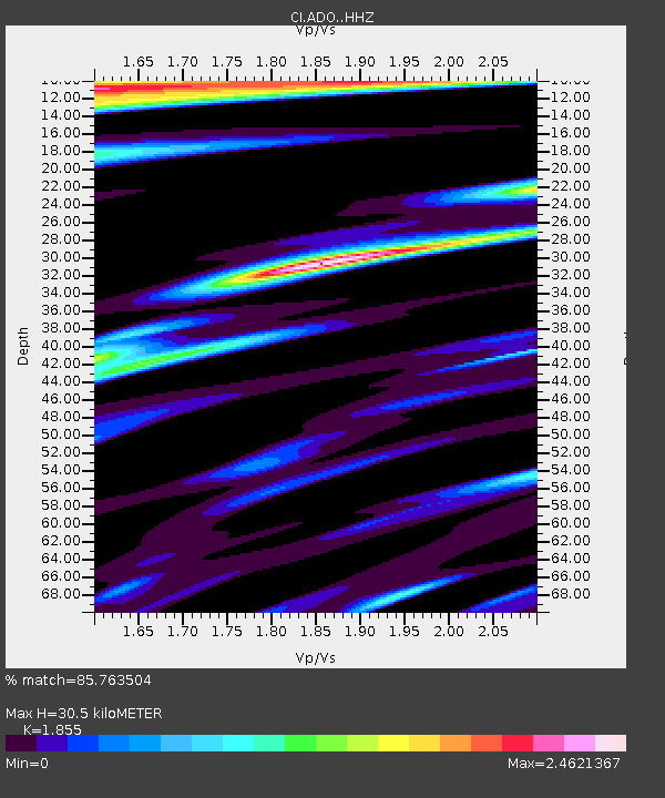
| Estimated Moho Depth: |
30.5 km |
| Estimated Crust Vp/Vs: |
1.86 |
| Assumed Crust Vp: |
6.276 km/s |
| Estimated Crust Vs: |
3.383 km/s |
| Estimated Crust Poisson's Ratio: |
0.30 |
|
| Radial Match: |
85.763504 % |
| Radial Bump: |
400 |
| Transverse Match: |
77.01388 % |
| Transverse Bump: |
400 |
| SOD ConfigId: |
13570011 |
| Insert Time: |
2019-05-02 19:50:43.684 +0000 |
| GWidth: |
2.5 |
| Max Bumps: |
400 |
| Tol: |
0.001 |
|
Signal To Noise
| Channel | StoN | STA | LTA |
| CI:ADO: :HHZ:20190328T22:16:24.06803Z | 5.8272166 | 3.841176E-6 | 6.591785E-7 |
| CI:ADO: :HHN:20190328T22:16:24.06803Z | 3.3399122 | 1.5408524E-6 | 4.613452E-7 |
| CI:ADO: :HHE:20190328T22:16:24.06803Z | 1.6516253 | 1.0201326E-6 | 6.176537E-7 |
| Arrivals |
| Ps | 4.3 SECOND |
| PpPs | 13 SECOND |
| PsPs/PpSs | 18 SECOND |


