You are here: Home > Network List > CN - Canadian National Seismograph Network Stations List
> Station CHEG Cheticamp, NS, CA > Earthquake Result Viewer
CHEG Cheticamp, NS, CA - Earthquake Result Viewer
| Earthquake location: |
East Of Kuril Islands |
| Earthquake latitude/longitude: |
50.5/160.0 |
| Earthquake time(UTC): |
2019/03/28 (087) 22:06:49 GMT |
| Earthquake Depth: |
9.0 km |
| Earthquake Magnitude: |
6.2 Mww |
| Earthquake Catalog/Contributor: |
NEIC PDE/us |
|
| Network: |
CN Canadian National Seismograph Network |
| Station: |
CHEG Cheticamp, NS, CA |
| Lat/Lon: |
46.81 N/60.67 W |
| Elevation: |
446 m |
|
| Distance: |
76.9 deg |
| Az: |
27.34 deg |
| Baz: |
334.724 deg |
| Ray Param: |
0.050677024 |
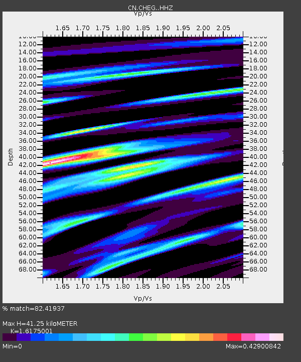
| Estimated Moho Depth: |
41.25 km |
| Estimated Crust Vp/Vs: |
1.62 |
| Assumed Crust Vp: |
6.291 km/s |
| Estimated Crust Vs: |
3.889 km/s |
| Estimated Crust Poisson's Ratio: |
0.19 |
|
| Radial Match: |
82.41937 % |
| Radial Bump: |
360 |
| Transverse Match: |
71.47248 % |
| Transverse Bump: |
400 |
| SOD ConfigId: |
13570011 |
| Insert Time: |
2019-05-02 19:51:41.871 +0000 |
| GWidth: |
2.5 |
| Max Bumps: |
400 |
| Tol: |
0.001 |
|

Signal To Noise
| Channel | StoN | STA | LTA |
| CN:CHEG: :HHZ:20190328T22:18:10.600012Z | 13.081685 | 2.4020849E-6 | 1.8362199E-7 |
| CN:CHEG: :HHN:20190328T22:18:10.600012Z | 6.1132107 | 8.433831E-7 | 1.3796074E-7 |
| CN:CHEG: :HHE:20190328T22:18:10.600012Z | 1.5643477 | 2.5164695E-7 | 1.6086382E-7 |
| Arrivals |
| Ps | 4.2 SECOND |
| PpPs | 17 SECOND |
| PsPs/PpSs | 21 SECOND |


