You are here: Home > Network List > IU - Global Seismograph Network (GSN - IRIS/USGS) Stations List
> Station PMG Port Moresby, New Guinea > Earthquake Result Viewer
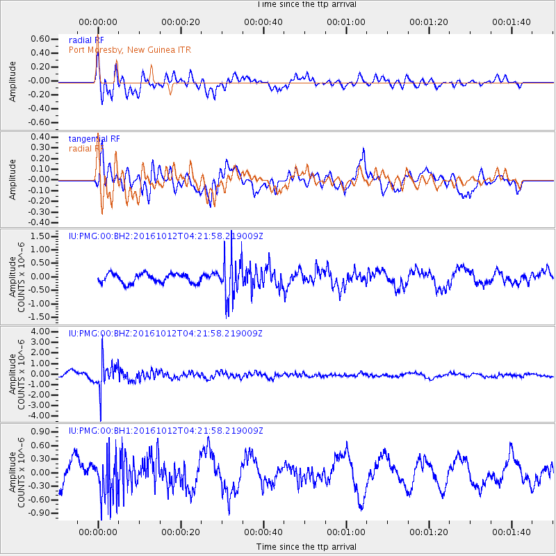
PMG Port Moresby, New Guinea - Earthquake Result Viewer
*The percent match for this event was below the threshold and hence no stack was calculated.
| Earthquake location: |
Fiji Islands Region |
| Earthquake latitude/longitude: |
-20.9/-178.6 |
| Earthquake time(UTC): |
2016/10/12 (286) 04:16:24 GMT |
| Earthquake Depth: |
575 km |
| Earthquake Magnitude: |
5.5 MB |
| Earthquake Catalog/Contributor: |
NEIC PDE/NEIC COMCAT |
|
| Network: |
IU Global Seismograph Network (GSN - IRIS/USGS) |
| Station: |
PMG Port Moresby, New Guinea |
| Lat/Lon: |
9.40 S/147.16 E |
| Elevation: |
90 m |
|
| Distance: |
34.9 deg |
| Az: |
283.906 deg |
| Baz: |
113.115 deg |
| Ray Param: |
$rayparam |
*The percent match for this event was below the threshold and hence was not used in the summary stack. |
|
| Radial Match: |
63.185886 % |
| Radial Bump: |
400 |
| Transverse Match: |
68.2591 % |
| Transverse Bump: |
400 |
| SOD ConfigId: |
1634031 |
| Insert Time: |
2016-10-26 04:17:52.228 +0000 |
| GWidth: |
2.5 |
| Max Bumps: |
400 |
| Tol: |
0.001 |
|
Signal To Noise
| Channel | StoN | STA | LTA |
| IU:PMG:00:BHZ:20161012T04:21:58.219009Z | 4.9648695 | 1.3694378E-6 | 2.7582553E-7 |
| IU:PMG:00:BH1:20161012T04:21:58.219009Z | 1.5891262 | 4.5367938E-7 | 2.8548982E-7 |
| IU:PMG:00:BH2:20161012T04:21:58.219009Z | 4.2982607 | 7.306725E-7 | 1.6999262E-7 |
| Arrivals |
| Ps | |
| PpPs | |
| PsPs/PpSs | |


