You are here: Home > Network List > CN - Canadian National Seismograph Network Stations List
> Station DLBC Dease Lake, BC, CA > Earthquake Result Viewer
DLBC Dease Lake, BC, CA - Earthquake Result Viewer
| Earthquake location: |
East Of Kuril Islands |
| Earthquake latitude/longitude: |
50.5/160.0 |
| Earthquake time(UTC): |
2019/03/28 (087) 22:06:49 GMT |
| Earthquake Depth: |
9.0 km |
| Earthquake Magnitude: |
6.2 Mww |
| Earthquake Catalog/Contributor: |
NEIC PDE/us |
|
| Network: |
CN Canadian National Seismograph Network |
| Station: |
DLBC Dease Lake, BC, CA |
| Lat/Lon: |
58.44 N/130.03 W |
| Elevation: |
978 m |
|
| Distance: |
39.7 deg |
| Az: |
50.689 deg |
| Baz: |
290.057 deg |
| Ray Param: |
0.074832186 |
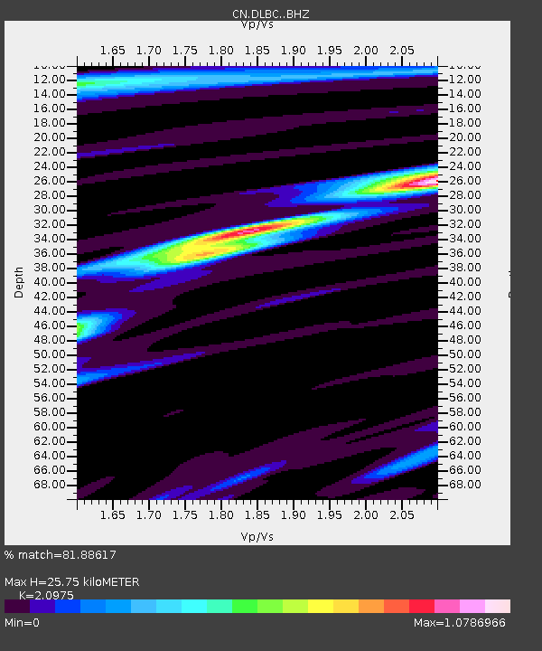
| Estimated Moho Depth: |
25.75 km |
| Estimated Crust Vp/Vs: |
2.10 |
| Assumed Crust Vp: |
6.597 km/s |
| Estimated Crust Vs: |
3.145 km/s |
| Estimated Crust Poisson's Ratio: |
0.35 |
|
| Radial Match: |
81.88617 % |
| Radial Bump: |
400 |
| Transverse Match: |
77.21919 % |
| Transverse Bump: |
400 |
| SOD ConfigId: |
13570011 |
| Insert Time: |
2019-05-02 19:51:46.166 +0000 |
| GWidth: |
2.5 |
| Max Bumps: |
400 |
| Tol: |
0.001 |
|

Signal To Noise
| Channel | StoN | STA | LTA |
| CN:DLBC: :BHZ:20190328T22:13:51.100012Z | 15.797928 | 3.749192E-6 | 2.3732177E-7 |
| CN:DLBC: :BHN:20190328T22:13:51.100012Z | 3.414754 | 6.779801E-7 | 1.9854436E-7 |
| CN:DLBC: :BHE:20190328T22:13:51.100012Z | 4.4224033 | 1.8235029E-6 | 4.12333E-7 |
| Arrivals |
| Ps | 4.6 SECOND |
| PpPs | 11 SECOND |
| PsPs/PpSs | 16 SECOND |


