You are here: Home > Network List > WY - Yellowstone Wyoming Seismic Network Stations List
> Station YHR Hawk's Rest, WY, USA > Earthquake Result Viewer
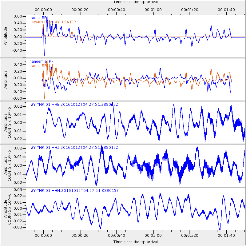
YHR Hawk's Rest, WY, USA - Earthquake Result Viewer
*The percent match for this event was below the threshold and hence no stack was calculated.
| Earthquake location: |
Fiji Islands Region |
| Earthquake latitude/longitude: |
-20.9/-178.6 |
| Earthquake time(UTC): |
2016/10/12 (286) 04:16:24 GMT |
| Earthquake Depth: |
575 km |
| Earthquake Magnitude: |
5.5 MB |
| Earthquake Catalog/Contributor: |
NEIC PDE/NEIC COMCAT |
|
| Network: |
WY Yellowstone Wyoming Seismic Network |
| Station: |
YHR Hawk's Rest, WY, USA |
| Lat/Lon: |
44.11 N/110.08 W |
| Elevation: |
2976 m |
|
| Distance: |
90.0 deg |
| Az: |
42.083 deg |
| Baz: |
240.435 deg |
| Ray Param: |
$rayparam |
*The percent match for this event was below the threshold and hence was not used in the summary stack. |
|
| Radial Match: |
60.163967 % |
| Radial Bump: |
400 |
| Transverse Match: |
42.21381 % |
| Transverse Bump: |
400 |
| SOD ConfigId: |
1634031 |
| Insert Time: |
2016-10-26 04:19:03.771 +0000 |
| GWidth: |
2.5 |
| Max Bumps: |
400 |
| Tol: |
0.001 |
|
Signal To Noise
| Channel | StoN | STA | LTA |
| WY:YHR:01:HHZ:20161012T04:27:51.388015Z | 1.0585855 | 8.51081E-9 | 8.039795E-9 |
| WY:YHR:01:HHN:20161012T04:27:51.388015Z | 0.8143691 | 8.086504E-9 | 9.929778E-9 |
| WY:YHR:01:HHE:20161012T04:27:51.388015Z | 1.1414986 | 9.364684E-9 | 8.203851E-9 |
| Arrivals |
| Ps | |
| PpPs | |
| PsPs/PpSs | |


