You are here: Home > Network List > DK - Danish Seismological Network Stations List
> Station KULLO Kullorsuaq, Greenland > Earthquake Result Viewer
KULLO Kullorsuaq, Greenland - Earthquake Result Viewer
| Earthquake location: |
East Of Kuril Islands |
| Earthquake latitude/longitude: |
50.5/160.0 |
| Earthquake time(UTC): |
2019/03/28 (087) 22:06:49 GMT |
| Earthquake Depth: |
9.0 km |
| Earthquake Magnitude: |
6.2 Mww |
| Earthquake Catalog/Contributor: |
NEIC PDE/us |
|
| Network: |
DK Danish Seismological Network |
| Station: |
KULLO Kullorsuaq, Greenland |
| Lat/Lon: |
74.58 N/57.22 W |
| Elevation: |
44 m |
|
| Distance: |
52.7 deg |
| Az: |
11.721 deg |
| Baz: |
330.995 deg |
| Ray Param: |
0.066565976 |
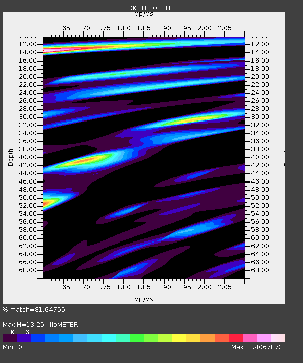
| Estimated Moho Depth: |
13.25 km |
| Estimated Crust Vp/Vs: |
1.60 |
| Assumed Crust Vp: |
6.424 km/s |
| Estimated Crust Vs: |
4.015 km/s |
| Estimated Crust Poisson's Ratio: |
0.18 |
|
| Radial Match: |
81.64755 % |
| Radial Bump: |
400 |
| Transverse Match: |
78.807106 % |
| Transverse Bump: |
400 |
| SOD ConfigId: |
13570011 |
| Insert Time: |
2019-05-02 19:52:50.856 +0000 |
| GWidth: |
2.5 |
| Max Bumps: |
400 |
| Tol: |
0.001 |
|

Signal To Noise
| Channel | StoN | STA | LTA |
| DK:KULLO: :HHZ:20190328T22:15:33.478003Z | 8.03514 | 3.4411523E-6 | 4.282629E-7 |
| DK:KULLO: :HHN:20190328T22:15:33.478003Z | 8.34675 | 1.6867376E-6 | 2.0208316E-7 |
| DK:KULLO: :HHE:20190328T22:15:33.478003Z | 2.8710592 | 1.0032404E-6 | 3.4943216E-7 |
| Arrivals |
| Ps | 1.3 SECOND |
| PpPs | 5.0 SECOND |
| PsPs/PpSs | 6.4 SECOND |


