You are here: Home > Network List > KO - Kandilli Observatory Digital Broadband Seismic Network Stations List
> Station GURO KO.GURO > Earthquake Result Viewer
GURO KO.GURO - Earthquake Result Viewer
| Earthquake location: |
East Of Kuril Islands |
| Earthquake latitude/longitude: |
50.5/160.0 |
| Earthquake time(UTC): |
2019/03/28 (087) 22:06:49 GMT |
| Earthquake Depth: |
9.0 km |
| Earthquake Magnitude: |
6.2 Mww |
| Earthquake Catalog/Contributor: |
NEIC PDE/us |
|
| Network: |
KO Kandilli Observatory Digital Broadband Seismic Network |
| Station: |
GURO KO.GURO |
| Lat/Lon: |
38.55 N/42.03 E |
| Elevation: |
1388 m |
|
| Distance: |
75.9 deg |
| Az: |
314.424 deg |
| Baz: |
35.567 deg |
| Ray Param: |
0.051337507 |
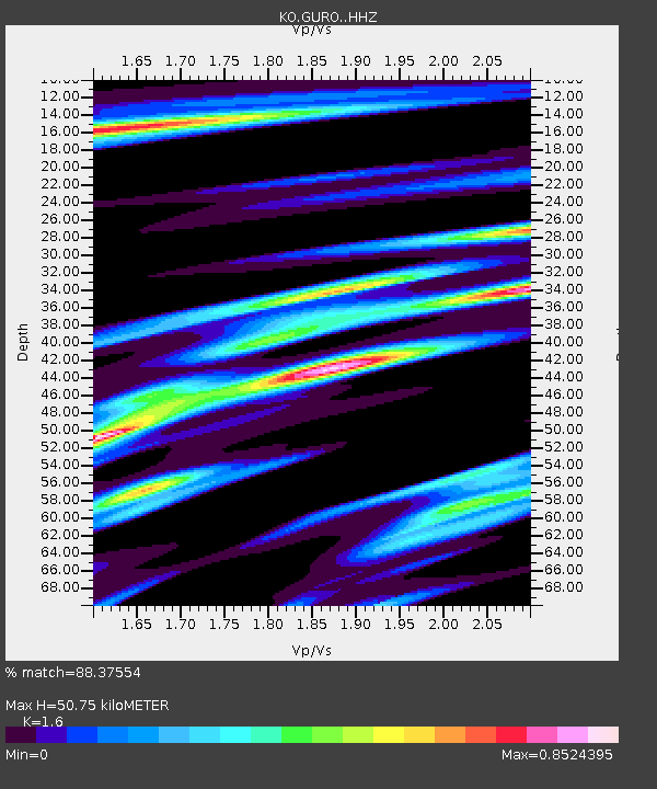
| Estimated Moho Depth: |
50.75 km |
| Estimated Crust Vp/Vs: |
1.60 |
| Assumed Crust Vp: |
6.35 km/s |
| Estimated Crust Vs: |
3.969 km/s |
| Estimated Crust Poisson's Ratio: |
0.18 |
|
| Radial Match: |
88.37554 % |
| Radial Bump: |
400 |
| Transverse Match: |
85.70025 % |
| Transverse Bump: |
400 |
| SOD ConfigId: |
13570011 |
| Insert Time: |
2019-05-02 19:54:04.932 +0000 |
| GWidth: |
2.5 |
| Max Bumps: |
400 |
| Tol: |
0.001 |
|

Signal To Noise
| Channel | StoN | STA | LTA |
| KO:GURO: :HHZ:20190328T22:18:05.050024Z | 49.15279 | 1.0917582E-6 | 2.2211522E-8 |
| KO:GURO: :HHN:20190328T22:18:05.050024Z | 4.5325303 | 4.854781E-7 | 1.0710973E-7 |
| KO:GURO: :HHE:20190328T22:18:05.050024Z | 4.669613 | 1.4128425E-7 | 3.0256096E-8 |
| Arrivals |
| Ps | 5.0 SECOND |
| PpPs | 20 SECOND |
| PsPs/PpSs | 25 SECOND |


