You are here: Home > Network List > LM - Michigan State University Seismic Network Stations List
> Station L48A N Adams, MI, USA > Earthquake Result Viewer
L48A N Adams, MI, USA - Earthquake Result Viewer
| Earthquake location: |
East Of Kuril Islands |
| Earthquake latitude/longitude: |
50.5/160.0 |
| Earthquake time(UTC): |
2019/03/28 (087) 22:06:49 GMT |
| Earthquake Depth: |
9.0 km |
| Earthquake Magnitude: |
6.2 Mww |
| Earthquake Catalog/Contributor: |
NEIC PDE/us |
|
| Network: |
LM Michigan State University Seismic Network |
| Station: |
L48A N Adams, MI, USA |
| Lat/Lon: |
41.94 N/84.43 W |
| Elevation: |
369 m |
|
| Distance: |
72.1 deg |
| Az: |
44.976 deg |
| Baz: |
322.77 deg |
| Ray Param: |
0.053856395 |
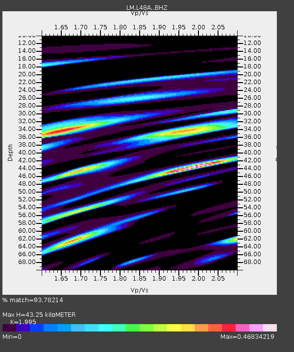
| Estimated Moho Depth: |
43.25 km |
| Estimated Crust Vp/Vs: |
2.00 |
| Assumed Crust Vp: |
6.498 km/s |
| Estimated Crust Vs: |
3.257 km/s |
| Estimated Crust Poisson's Ratio: |
0.33 |
|
| Radial Match: |
93.78214 % |
| Radial Bump: |
400 |
| Transverse Match: |
82.300285 % |
| Transverse Bump: |
400 |
| SOD ConfigId: |
13570011 |
| Insert Time: |
2019-05-02 19:54:47.973 +0000 |
| GWidth: |
2.5 |
| Max Bumps: |
400 |
| Tol: |
0.001 |
|

Signal To Noise
| Channel | StoN | STA | LTA |
| LM:L48A: :BHZ:20190328T22:17:42.999976Z | 22.711246 | 3.6094636E-6 | 1.5892847E-7 |
| LM:L48A: :BHN:20190328T22:17:42.999976Z | 11.490947 | 1.4590105E-6 | 1.2697043E-7 |
| LM:L48A: :BHE:20190328T22:17:42.999976Z | 7.873428 | 1.1867204E-6 | 1.5072474E-7 |
| Arrivals |
| Ps | 6.8 SECOND |
| PpPs | 19 SECOND |
| PsPs/PpSs | 26 SECOND |


