You are here: Home > Network List > MU - Miami University Seismic Network Stations List
> Station MUM1 Monroe > Earthquake Result Viewer
MUM1 Monroe - Earthquake Result Viewer
| Earthquake location: |
East Of Kuril Islands |
| Earthquake latitude/longitude: |
50.5/160.0 |
| Earthquake time(UTC): |
2019/03/28 (087) 22:06:49 GMT |
| Earthquake Depth: |
9.0 km |
| Earthquake Magnitude: |
6.2 Mww |
| Earthquake Catalog/Contributor: |
NEIC PDE/us |
|
| Network: |
MU Miami University Seismic Network |
| Station: |
MUM1 Monroe |
| Lat/Lon: |
39.65 N/81.15 W |
| Elevation: |
310 m |
|
| Distance: |
75.5 deg |
| Az: |
44.297 deg |
| Baz: |
324.716 deg |
| Ray Param: |
0.051650207 |
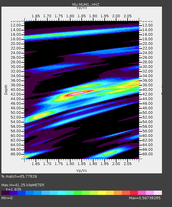
| Estimated Moho Depth: |
41.25 km |
| Estimated Crust Vp/Vs: |
1.84 |
| Assumed Crust Vp: |
6.207 km/s |
| Estimated Crust Vs: |
3.383 km/s |
| Estimated Crust Poisson's Ratio: |
0.29 |
|
| Radial Match: |
85.77926 % |
| Radial Bump: |
400 |
| Transverse Match: |
62.68768 % |
| Transverse Bump: |
400 |
| SOD ConfigId: |
13570011 |
| Insert Time: |
2019-05-02 19:54:59.155 +0000 |
| GWidth: |
2.5 |
| Max Bumps: |
400 |
| Tol: |
0.001 |
|

Signal To Noise
| Channel | StoN | STA | LTA |
| MU:MUM1: :HHZ:20190328T22:18:02.41001Z | 16.288158 | 1.0802298E-5 | 6.631995E-7 |
| MU:MUM1: :HHN:20190328T22:18:02.41001Z | 4.284066 | 3.249324E-6 | 7.584673E-7 |
| MU:MUM1: :HHE:20190328T22:18:02.41001Z | 4.065188 | 2.9553091E-6 | 7.269797E-7 |
| Arrivals |
| Ps | 5.7 SECOND |
| PpPs | 18 SECOND |
| PsPs/PpSs | 24 SECOND |


