You are here: Home > Network List > O2 - Oklahoma Consolidated Temporary Seismic Networks Stations List
> Station SC02 Maysville, Garvin & McClain Counties, OK, USA > Earthquake Result Viewer
SC02 Maysville, Garvin & McClain Counties, OK, USA - Earthquake Result Viewer
| Earthquake location: |
East Of Kuril Islands |
| Earthquake latitude/longitude: |
50.5/160.0 |
| Earthquake time(UTC): |
2019/03/28 (087) 22:06:49 GMT |
| Earthquake Depth: |
9.0 km |
| Earthquake Magnitude: |
6.2 Mww |
| Earthquake Catalog/Contributor: |
NEIC PDE/us |
|
| Network: |
O2 Oklahoma Consolidated Temporary Seismic Networks |
| Station: |
SC02 Maysville, Garvin & McClain Counties, OK, USA |
| Lat/Lon: |
34.80 N/97.39 W |
| Elevation: |
310 m |
|
| Distance: |
71.2 deg |
| Az: |
58.016 deg |
| Baz: |
318.839 deg |
| Ray Param: |
0.054477636 |
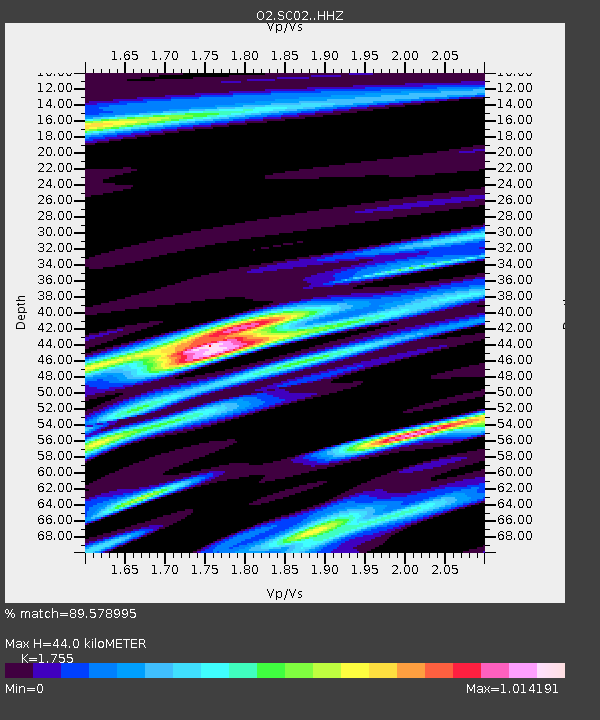
| Estimated Moho Depth: |
44.0 km |
| Estimated Crust Vp/Vs: |
1.75 |
| Assumed Crust Vp: |
6.426 km/s |
| Estimated Crust Vs: |
3.662 km/s |
| Estimated Crust Poisson's Ratio: |
0.26 |
|
| Radial Match: |
89.578995 % |
| Radial Bump: |
346 |
| Transverse Match: |
73.66167 % |
| Transverse Bump: |
400 |
| SOD ConfigId: |
13570011 |
| Insert Time: |
2019-05-02 19:56:29.162 +0000 |
| GWidth: |
2.5 |
| Max Bumps: |
400 |
| Tol: |
0.001 |
|

Signal To Noise
| Channel | StoN | STA | LTA |
| O2:SC02: :HHZ:20190328T22:17:37.360022Z | 29.754814 | 7.554518E-6 | 2.538923E-7 |
| O2:SC02: :HHN:20190328T22:17:37.360022Z | 5.5960464 | 2.413194E-6 | 4.3123194E-7 |
| O2:SC02: :HHE:20190328T22:17:37.360022Z | 6.3632684 | 2.5972006E-6 | 4.081551E-7 |
| Arrivals |
| Ps | 5.4 SECOND |
| PpPs | 18 SECOND |
| PsPs/PpSs | 24 SECOND |


