You are here: Home > Network List > O2 - Oklahoma Consolidated Temporary Seismic Networks Stations List
> Station SC07 Cyril, Oklahoma, USA > Earthquake Result Viewer
SC07 Cyril, Oklahoma, USA - Earthquake Result Viewer
| Earthquake location: |
East Of Kuril Islands |
| Earthquake latitude/longitude: |
50.5/160.0 |
| Earthquake time(UTC): |
2019/03/28 (087) 22:06:49 GMT |
| Earthquake Depth: |
9.0 km |
| Earthquake Magnitude: |
6.2 Mww |
| Earthquake Catalog/Contributor: |
NEIC PDE/us |
|
| Network: |
O2 Oklahoma Consolidated Temporary Seismic Networks |
| Station: |
SC07 Cyril, Oklahoma, USA |
| Lat/Lon: |
34.93 N/98.21 W |
| Elevation: |
349 m |
|
| Distance: |
70.7 deg |
| Az: |
58.461 deg |
| Baz: |
318.515 deg |
| Ray Param: |
0.054838017 |
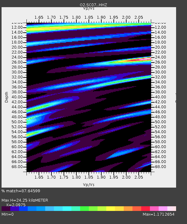
| Estimated Moho Depth: |
24.25 km |
| Estimated Crust Vp/Vs: |
2.10 |
| Assumed Crust Vp: |
6.315 km/s |
| Estimated Crust Vs: |
3.011 km/s |
| Estimated Crust Poisson's Ratio: |
0.35 |
|
| Radial Match: |
87.64599 % |
| Radial Bump: |
400 |
| Transverse Match: |
65.76507 % |
| Transverse Bump: |
400 |
| SOD ConfigId: |
13570011 |
| Insert Time: |
2019-05-02 19:56:32.874 +0000 |
| GWidth: |
2.5 |
| Max Bumps: |
400 |
| Tol: |
0.001 |
|

Signal To Noise
| Channel | StoN | STA | LTA |
| O2:SC07: :HHZ:20190328T22:17:34.03501Z | 13.654556 | 7.688272E-6 | 5.630554E-7 |
| O2:SC07: :HHN:20190328T22:17:34.03501Z | 4.0101714 | 1.5113667E-6 | 3.7688332E-7 |
| O2:SC07: :HHE:20190328T22:17:34.03501Z | 3.6860693 | 1.4170946E-6 | 3.8444603E-7 |
| Arrivals |
| Ps | 4.3 SECOND |
| PpPs | 12 SECOND |
| PsPs/PpSs | 16 SECOND |


