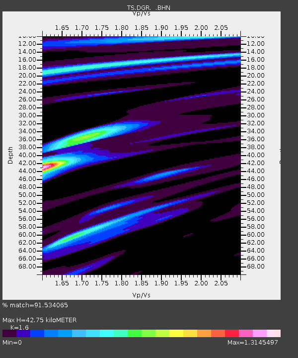
DGR Domenigoni Valley Reservior, California, USA - Earthquake Result Viewer
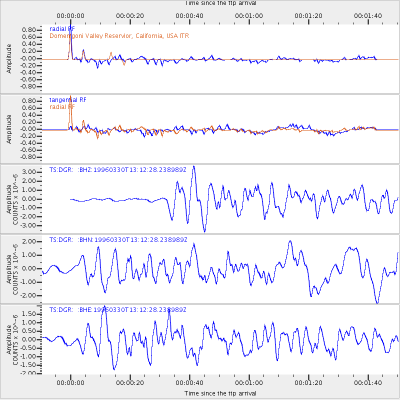
Earthquake location: Fox Islands, Aleutian Islands
Earthquake latitude/longitude: 52.2/-168.7
Earthquake time(UTC): 1996/03/30 (090) 13:05:17 GMT
Earthquake Depth: 33 km
Earthquake Magnitude: 5.9 MB, 6.2 MS, 6.3 UNKNOWN, 6.1 ML
Earthquake Catalog/Contributor: WHDF/NEIC
Network: TS TERRAscope (Southern California Seismic Network)
Station: DGR Domenigoni Valley Reservior, California, USA
Lat/Lon: 33.65 N/117.01 W
Elevation: 700 m
Distance: 41.2 deg
Az: 95.925 deg
Baz: 312.804 deg
Ray Param: 0.07388975
Estimated Moho Depth: 42.75 km
Estimated Crust Vp/Vs: 1.60
Assumed Crust Vp: 6.264 km/s
Estimated Crust Vs: 3.915 km/s
Estimated Crust Poisson's Ratio: 0.18
Radial Match: 91.534065 %
Radial Bump: 377
Transverse Match: 65.60737 %
Transverse Bump: 400
SOD ConfigId: 6273
Insert Time: 2010-02-26 14:09:03.931 +0000
GWidth: 2.5
Max Bumps: 400
Tol: 0.001

Signal To Noise

ChannelStoNSTALTA
TS:DGR: :BHN:19960330T13:12:28.238989Z2.48552565.0490013E-72.0313615E-7
TS:DGR: :BHE:19960330T13:12:28.238989Z2.46499923.466609E-71.4063326E-7
TS:DGR: :BHZ:19960330T13:12:28.238989Z9.800769.945102E-71.0147275E-7
Arrivals
Ps4.4 SECOND
PpPs17 SECOND
PsPs/PpSs21 SECOND