You are here: Home > Network List > IU - Global Seismograph Network (GSN - IRIS/USGS) Stations List
> Station ADK Adak, Aleutian Islands, Alaska > Earthquake Result Viewer
ADK Adak, Aleutian Islands, Alaska - Earthquake Result Viewer
| Earthquake location: |
New Britain Region, P.N.G. |
| Earthquake latitude/longitude: |
-4.3/150.4 |
| Earthquake time(UTC): |
2016/10/15 (289) 08:03:39 GMT |
| Earthquake Depth: |
451 km |
| Earthquake Magnitude: |
6.0 MB |
| Earthquake Catalog/Contributor: |
NEIC PDE/NEIC ALERT |
|
| Network: |
IU Global Seismograph Network (GSN - IRIS/USGS) |
| Station: |
ADK Adak, Aleutian Islands, Alaska |
| Lat/Lon: |
51.88 N/176.68 W |
| Elevation: |
130 m |
|
| Distance: |
62.6 deg |
| Az: |
22.3 deg |
| Baz: |
217.626 deg |
| Ray Param: |
0.05854912 |
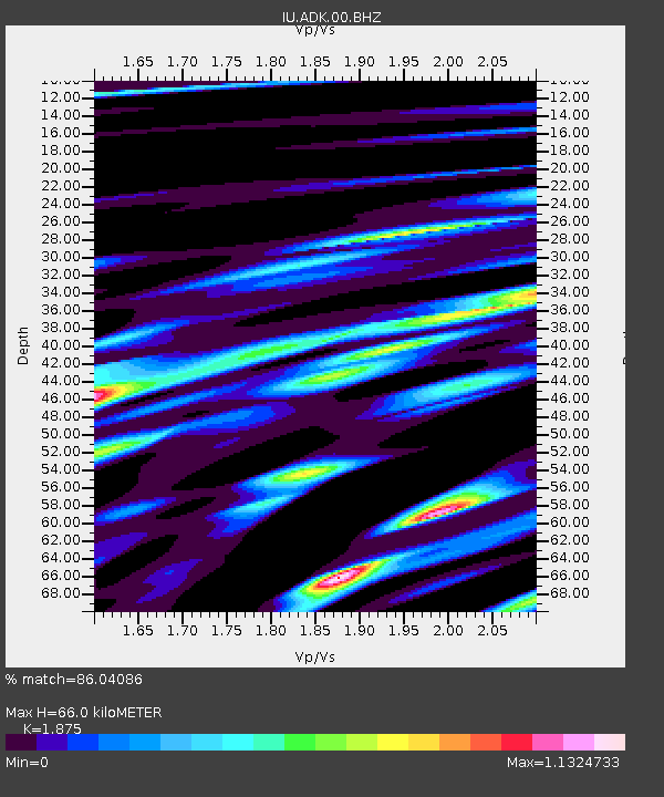
| Estimated Moho Depth: |
66.0 km |
| Estimated Crust Vp/Vs: |
1.88 |
| Assumed Crust Vp: |
5.88 km/s |
| Estimated Crust Vs: |
3.136 km/s |
| Estimated Crust Poisson's Ratio: |
0.30 |
|
| Radial Match: |
86.04086 % |
| Radial Bump: |
400 |
| Transverse Match: |
76.31548 % |
| Transverse Bump: |
400 |
| SOD ConfigId: |
1634031 |
| Insert Time: |
2016-10-29 08:06:34.715 +0000 |
| GWidth: |
2.5 |
| Max Bumps: |
400 |
| Tol: |
0.001 |
|

Signal To Noise
| Channel | StoN | STA | LTA |
| IU:ADK:00:BHZ:20161015T08:12:46.718994Z | 17.618813 | 9.084506E-6 | 5.15614E-7 |
| IU:ADK:00:BH1:20161015T08:12:46.718994Z | 9.066099 | 3.5531637E-6 | 3.9191758E-7 |
| IU:ADK:00:BH2:20161015T08:12:46.718994Z | 4.7430434 | 2.3353657E-6 | 4.92377E-7 |
| Arrivals |
| Ps | 10 SECOND |
| PpPs | 31 SECOND |
| PsPs/PpSs | 41 SECOND |


