You are here: Home > Network List > RM - Regional Integrated Multi Hazard Early Warning System Stations List
> Station SZP Santa Ilocos Sur > Earthquake Result Viewer
SZP Santa Ilocos Sur - Earthquake Result Viewer
| Earthquake location: |
East Of Kuril Islands |
| Earthquake latitude/longitude: |
50.5/160.0 |
| Earthquake time(UTC): |
2019/03/28 (087) 22:06:49 GMT |
| Earthquake Depth: |
9.0 km |
| Earthquake Magnitude: |
6.2 Mww |
| Earthquake Catalog/Contributor: |
NEIC PDE/us |
|
| Network: |
RM Regional Integrated Multi Hazard Early Warning System |
| Station: |
SZP Santa Ilocos Sur |
| Lat/Lon: |
17.55 N/120.46 E |
| Elevation: |
100 m |
|
| Distance: |
45.5 deg |
| Az: |
238.288 deg |
| Baz: |
34.711 deg |
| Ray Param: |
0.071228966 |
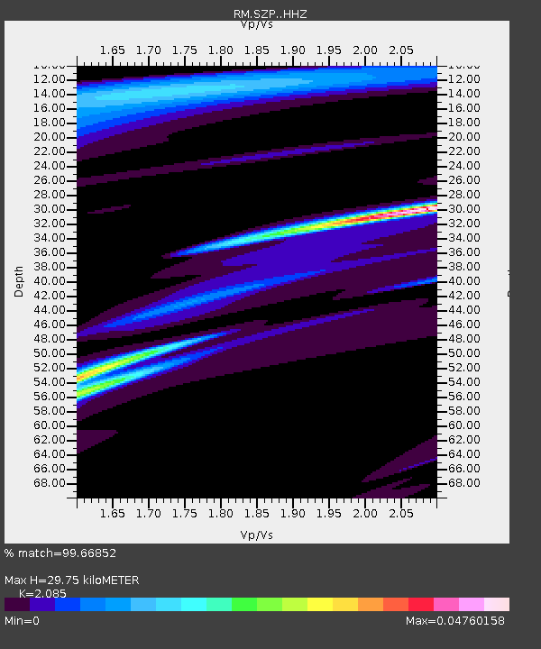
| Estimated Moho Depth: |
29.75 km |
| Estimated Crust Vp/Vs: |
2.09 |
| Assumed Crust Vp: |
6.468 km/s |
| Estimated Crust Vs: |
3.102 km/s |
| Estimated Crust Poisson's Ratio: |
0.35 |
|
| Radial Match: |
99.66852 % |
| Radial Bump: |
52 |
| Transverse Match: |
73.50183 % |
| Transverse Bump: |
400 |
| SOD ConfigId: |
13570011 |
| Insert Time: |
2019-05-02 19:57:45.067 +0000 |
| GWidth: |
2.5 |
| Max Bumps: |
400 |
| Tol: |
0.001 |
|

Signal To Noise
| Channel | StoN | STA | LTA |
| RM:SZP: :HHZ:20190328T22:14:38.217993Z | 24.47092 | 5.060274E-6 | 2.0678723E-7 |
| RM:SZP: :HHN:20190328T22:14:38.217993Z | 16.203253 | 3.0531223E-6 | 1.8842651E-7 |
| RM:SZP: :HHE:20190328T22:14:38.217993Z | 20.719868 | 2.677187E-6 | 1.2920869E-7 |
| Arrivals |
| Ps | 5.3 SECOND |
| PpPs | 13 SECOND |
| PsPs/PpSs | 19 SECOND |


